Day 54: Bulls to Fielding (Colyton)

Day 54: Bulls to Fielding (Colyton)

Distance travelled today: 24 km

Total TA distance covered: 1458 km

The kindness of strangers.

Today was a fairly easy day. Another day of pure road walking from Bulls to Fielding. The main mission of the day was to reach Fielding and just beyond before forecast heavy rains commenced in the afternoon. Checking the forecast last night I was expecting to be walking in light to moderate rain all day towards Fielding but it never came.

It was quick walking on the backroads with very little traffic for the most part. It was early and a Sunday which may have been part of the reason. I reached an Airforce radar station around 6 km and pulled up for a short break, entertained by a Tui jumping from flower to flower. Turning onto Ngaio Road and Stewarts Road the traffic increased a bit but all drivers were great, pulling well into the middle of the road to give me some space. The trail is welled marked through the back blocks here with directional arrows on just about every corner which made for easy navigation.

image

I reached Fielding around mid day and spent a couple of hours having a lesuirely lunch and coffee in town.

By far one of the biggest highlights of my trip thus far was the absolute generousity and kindness of a complete stranger and blog follower, Arran. Arran emailed me a week or so ago saying that if I was passing through Fielding I was welcome to call through and stay. I took him up on this offer and made arrangements to walk through Fielding and get picked up at the start of their road as the property was 6km off trail.

Talk about timing. I’d left Fielding enroute out of town as the drissly rain started to settle in. The wet weather gear was on but not needed for long. Around 2km out of town, Arran drove past on the way to the shops, saw me and stopped to picked me up. What a pleasure to meet such a genuine Kiwi bloke and later his family. I was welcomed into the family home like a family member and made to feel right at home. Perfect as the rain started to belt down outside. Later I met the rest of the gang as they returned home from the movies, young Lenny (8yrs) and very inqusitive Oscar (4yrs), as well as Mia (14) and Arran’s wife Poppy.

I was expecting to pitch my tent in the back yard and perhaps be able to have a warm shower but I was treated to so much more. A pork roast dinner with pudding and hokey pokey icecream for desert; a couple of beers; warm shower and a soft warm bed to sleep in. So much more than I could ever wish for and completly unexpected. The kindness of Kiwi’s has been a highlight of the Te Araroa right the way through. I spent the afternoon making use of unlimited wifi to update photos and my blog; and being entertained by the lively young fellas, playing heaps of games and answering many, many questions they had about absolutely everything. They were great and it was fun to get a kid fix for a while, reminding me of my many young nephews.

To top my stay with Arran and his family off, I slept like a log, got to have a sleep in and was treated to a breakfast of bacon and eggs. Thankyou so such guys!! Your generosity was very much apprecaiated.

Oscar, Arran & Lenny

Oscar, Arran & Lenny


Day 53: Stantof Forest to Bulls

Day 53: Stantof Forest to Bulls

Distance travelled today: 14 km

Total TA distance covered: 1434 km

Short day today.

It rained overnight and into the morning which I expected but had a short day ahead and decided to sleep in a bit until I heard the rain start to peatier out. I got packed up and was on the way by 8:30am, a late start for me but I was no hurry today. I was fully expecting to be walking in the rain today but it stayed away for the whole walk into town.

Another uneventful walk on a forest road through harvested pines and then onto the bitumen the rest of the way into Bulls. I kept myself entertained listening to podcasts from some of my favourite sources like TED talks, Ockham’s Razor and Point of Inquiry. One podcast was all about slowing down which fitted perfectly for my Te Araroa trip. One in particular was about cloud watching which I’ve found myself doing more and more during rest breaks or at the end of the day. It’s like a meditation, a chance to slow down and do nothing, just be present in the moment, observing the environment around me and letting my immagination run wild. To be able to sit still for just a few minutes to reflect on the day, to contemplate and find out what really moves us, to recall where our truest happiness lies, is an art I’m learning to appreciate more and more. But it can bring up some challenging moments like that sometimes making a living and making a life often point in opposite directions. These are the sort of things I want to think about along Te Araroa.

“…in an age of acceleration, nothing can be more exhilarating than going slow. And in an age of distraction, nothing is so luxurious as paying attention. And in an age of constant movement, nothing is so urgent as sitting still. So you can go on your next vacation to Paris or Hawaii, or New Orleans; I bet you’ll have a wonderful time. But, if you want to come back home alive and full of fresh hope, in love with the world, I think you might want to try considering going nowhere.”

Ok we’re getting a bit too Zen now….

While walking along the road towards town I was treated to an aerial display from a crop duster. I’m pretty sure he was just practicing low level flying cutting tight laps overhead, sweeping down to tree top level but the pilot never deployed anything. It reminded me of fighting fires back home with bombers coming in low to drop retardant. The pilot saw me on the road and rocked his wings side to side as I waved.

I arrived into Bulls around 12pm and headed for the bakery. Bulls is proud of being Bulls and all around town there were signs with Bull puns everywhere. All the bins were lablelled Be Responsabull, the police house has a mural with a Constabull, the town hall signed A Town Like No Udder, the toilet block with Releifabull etc… even the backpackers was Hostipabull.

Anyway, in the bakery I had the pleasure of meeting aspiring B&B operator and lively Michelle who immediately struck up a consevation seeing that I was walking Te Araroa and invited me back to her place for a cup of tea. In the spirit of not passing up opportunities I obliged. Michelle and her partner Luke were in the process of kicking off a B&B, although still a work in progress and trying to attract the attention of  Te Araroa trampers. They were very keen know and to quiz me about all that is TA: where are the main sources of info for trampers; how they might get listed as a provider for accommodation, how trampers share info on the facebook pages etc… I bought my pie, apple slice and coffee back to Michelle and Luke’s place where we sat around a fire pot in the backyard and just talked. I had a coffee in hand so didn’t need tea. The conversation was completely free flowing both ways and we covered all manner of topics not just theTe Araroa. It was great to meet yet more genuine local people who were wanting to meet and assist Te Araroa trampers. True charcaters. But time got away from us. I looked at my watch and it was time to keep moving on. I’m sure I could have easily stayed there but I had a few things to do in town and had accommodation paid for further down the line.

image

Tomorrow is expected to be very rainy so I’m glade to have a shelter overhead tonight which means a dry pack up in the morning but I’m not looking forward to walking all day in the rain. At least it’s on roads and should make for fast walking.

image

Interesting letter boxes along the way

image

Day 52: Whanganui to Stantof Forest

Distance travelled today: 45 km, plus 5km ride on Hwy 1

Total TA distance covered: 1420 km

Back into it and back on the roads & beach.

It was great to get back onto my feet and walking after a weeks paddling on the river but I’d already forgotten how heavy a freshly resupplied pack with water was. I had a feeling that it would be dry camping tonight so I was carrying 2.5 litres of water as well as 2.5 days food. But it didn’t take long to get back into the swing of things.

It was an uneventful day really with basically just road walking and a short 7 km section of beach from Koitiata before hitting the pines and forestry roads of the Stantof Forest. Today was a day of head down, ipod in listening to podcasts and one of keeping the feet moving.

It has been such a long time since walking on a beach too that I’d forgotten how hard it was on the feet in soft sand with an incoming tide. Koitiata struck me as  Marlo in New Zealand. Similar sized beach side town full of holiday markers for the Christmas/New Year holiday period. Shout out to all my Marlo friends dealing with the annual inundation of tourists.

The black sands of Koitiata were in stark contrast to all the other beaches walked thus far with quartz white sands. Sun bleached skeletons of trees littered the entire beach and it looked like the exposed bones and thousands of dinosaurs.

image

What really amazed me along the beach was the number of people stopping me to ask where I was headed and why. Not a single one of them had heard of Te Araroa. They all thought I was crazy. It was as if walking more than 200 m  for anything for them was the stupidist thing ever. I got sick of comments like “We have buses you know!”, “Why would you want to do that?”. I just kept reminding myself that these are typical city folk out for their annual summer vacation to the same spot they’ve been visiting for the last 20 years and too caught up in the comfot of their own micro world; not at all typical of all the other amazing locals I’ve met right along the way. Towards the end and after countless short conversations repeating the same answers I started to get a little annoyed and started to cut people off with statements like ” If you have to ask the question, you will never understand why I’m doing this” and walked on.

image

The sun was out in force today too which made for hot going and frequent breaks. Sun screen applied liberally to my pale skin immediately collected any black sand that was blown up by the winds. It was great to have a quick swim at the end of the beach to cool down and wash off a bit before heading inland again.

The days was getting on and I started to ration my water, knowing that I still had a way to go before reaching a camp site, and would need enough for the night and morning if sleeping out. Luckly I topped up before the beach.

I got more distance in than I ever thought I would but finally pulled up stumps arpund 6:30pm to settle into a sheltered spot amongst the cover of pines near the TA 1420 km mark, exhausted. A thick cover of pine needles on the forest floor providing a nice cushioned camp for the night and the trees overhead providing some shelter from the rain that was expected to commence overnight and hang around for a few days.

Day 51: Whanganui Zero Day

Distance travelled today: 0 km

Choices and hard decisions.

Taking a day off after 7 days on the river provided an opportunity to get resupplied and start planning ahead for the next leg on Te Araroa. I still amazes me that for is a relative simple way of travelling across a country there is still quite a bit of organisation required, logistics and thinking ahead. Thinking about where I might be in say a week and planning according. This next section is no exception and there are quite a few things going on in the next few weeks. To start we I have 5 days to fill before meeting Sarah in Palmerston North; Wellington is not that far away and Jacinta is coming over for a long weekend on the 22nd.

Leading up to the 5th I had a few options. My main one was travel back north and complete the Tongariro Alpine Crossing but the weather just isn’t playing the game. The next 3 days are excpected to bring gale force winds, rain and the potential for snow with a low mixing level. While I’m confident I could handle the wind, with the rain comes cloud and I’m not sure I want to attempt the crossing with no views to he had across such spectacular country. What would be the point? And I don’t really have the time to sit and wait in National Park or Whakapapa for 3 days for the weather to clear. So it was that the really hard decision was made to skip the crossing and wait for another opportunity in the future. This is disappointing. It is the second time I’ve been pushed off the mountain due to bad weather and is a real highlight section of Te Araroa. So I’ll continue on foot and walk from Whanganui towards Palmerston North via Bulls and Fielding over the next few days. This also brings opportunities. Aaron, a blog follower, reached out and offered trail magic on my way through Fielding, offering a place to camp and a shower. That is perfect and yet another example of the amazing New Zealand hospitality. Thanks Aaron, I look forawrd to meeting you and your family. Continuing to travel south also sets me up well to meet with Sarah on time before we take on the Tararua Range.

With each step taken, Wellington approaches closer as well. Having a day off in town has allowed me to review my Interislander crossing from Wellington to Picton and ammend my travel date, bringing it foward by two weeks. In sponsoring my Te Araroa journey, Interislander provided a free and upgraded crossing of the Cook Strait. This was organised prior to leaving home and to confirm a ticket they needed to pencil in a date which at the time was Jan 28th. I’m way ahead of this date and it was great to be able to bring it forward. Thanks again Interislander. This also gives me some real focus now too. Having a date to aim for makes things all the more concrete and gives a solid dead line to finish the north island and move onto the south. I’m ready reaching a new milestone and at the moment it is finishing the north island. Although just out of Palmerston North in about five days I will reach the 1500km mark and the half way point. Wellington sits around the 1700 km mark.

The south island will be quicker than the north. Much more trail time and less towns to get caught up in wasting time and draining the bank account.

Skyping home last night, Jacinta and I nowvhave a vague plan to meet up on the weekend of the 22nd. This will give me plenty of time to cross over the south island and complete the Queen Charlotte Track section of Te Araroa. From there we will meet up, with me either hitching out to a town if I have a day spare for Jacinta meeting me near Havelock at the end of the QCT.

So, resupplied, a few weeks planned ahead and well fed in town, In had the opportunity to do a few toursity things around town.

image

It’s New Years Eve tonight and with the morning brings another year but for me it is just another day and tonight will be very quiet, getting packed up and making a few repairs to gear that is starting to shows the signs of 2 months thru hiking.

image

Days 44 to 50: Whanganui River Journey

Distance travelled: 228 km paddling over 7 days

Total TA distance covered: 1375 km

Instead of the usual day by day account of my Te Araroa adventure I’ve packaged up the whole Whanganui River Journey into one blog post. The river was fantastic but nearly every day was the same with minor differences that don’t really warrant a separate entry for each day.

From Taumarunui, Te Araroa trampers have multiple options on the route to follow. The official trail and for those that are wanting to complete every single kilometre the trail heads east for two days to take in the 42nd traverse on quad bike trails, across to the Tongariro Alpine Crossing for 2 days and another 1 to 2 days of road walking to reack Whakahoro on the Whanganui River. From there trampers have the option of jumping onto the river or continuing for an additional 2 days of trail to Mangapurua and onto the river. From Mangapurua there is no option but the river.

For a group of us, we decided that organising to have canoes/kayaks delivered to us by jet boat to either Whakahoro or Mangapurua and only having 2 or 3 days on the mighty Whangual was logistically challenging (although it can and is usually done) and didn’t allow enough time to take in all that the river has to offer. So we made the decision to paddle as much of the river as we could from Taumarunui to Whanganui over 7 days. Sure it’s a deviation from the official TA trail but it maintains a continual line south and we would yoyo back to do the Tongariro crossing. So my TA distances get a bit mucked up from here but they would anyway on the south island as I plan a 2nd deviation away from Wanaka to Queenstown, instead planning to go from Wanaka – Cascade Saddle – Dart Track – Glenorchy and back onto the TA route. From here on in I’ll likely record the total distance covered in conjunction with the corresponding TA kilometre mark.

So it was that Chris & Cathi from Germany who I’ve travelled the trail on and off with since Ahipara; Antoine & Solenne from France who I met in Mangawhai Heads and Jurgen hooked up to take on the Whanganui River.

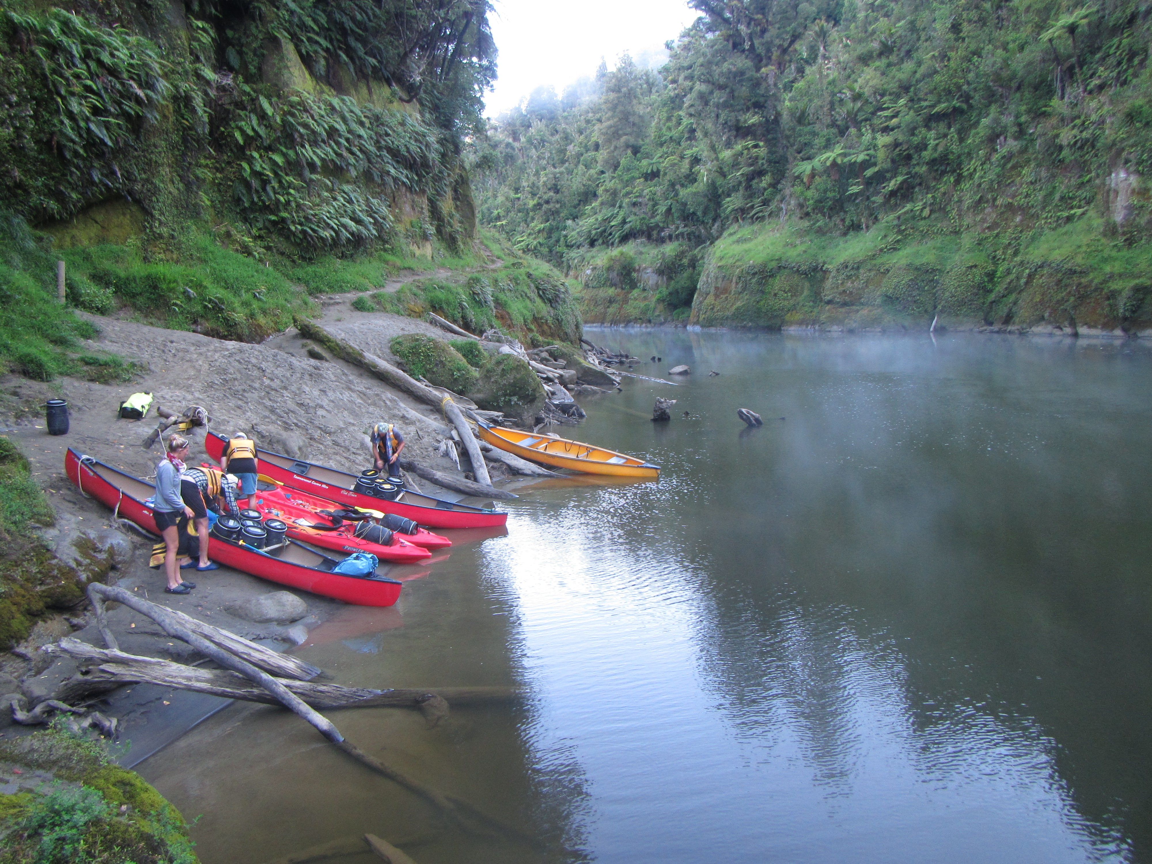
Jurgen and myself opted for sit on top kayaks as Jurgen was only going as far as Pipiriki, while the others jumped into canoes. Packing our gear into barrels and dry bags was a change but allowed us to carry a lot more than we typically would if walking including fresh food, heaps more snacks and beers. We were looking forward to Christmas on the river.

image

We planned out days to similar distances that we would cover each day on foot and were looking forward to giving the legs a break. It was like a mini break in the middle of a much bigger journey. What we covered:

Day 44: Taumarunui to Poukaria: 32 km

Day 45: Poukaria to Mangapapa: 32 km

Day 46: Mangapapa to Mangawaiiti: 36 km

Day 47: Mangapapa to Ngaporo: 32 km

Day 48: Ngaporo to Koriniti: 37 km

Day 49: Korinti to around km 1345: 30 km

Day 50: km 1345 to Whanganui: 25 km

Total distance on the river: 228 km

TA distance at end of the river: 1375 km

Highlights for the journey were many. Here are just a few:

Most enjoyabley, at least for the first 5 days, were being able to rest the feet and let the arms do some work. After 5 days though the arms had had enough but did what my legs keep doing, in findind that extra something to keep going.

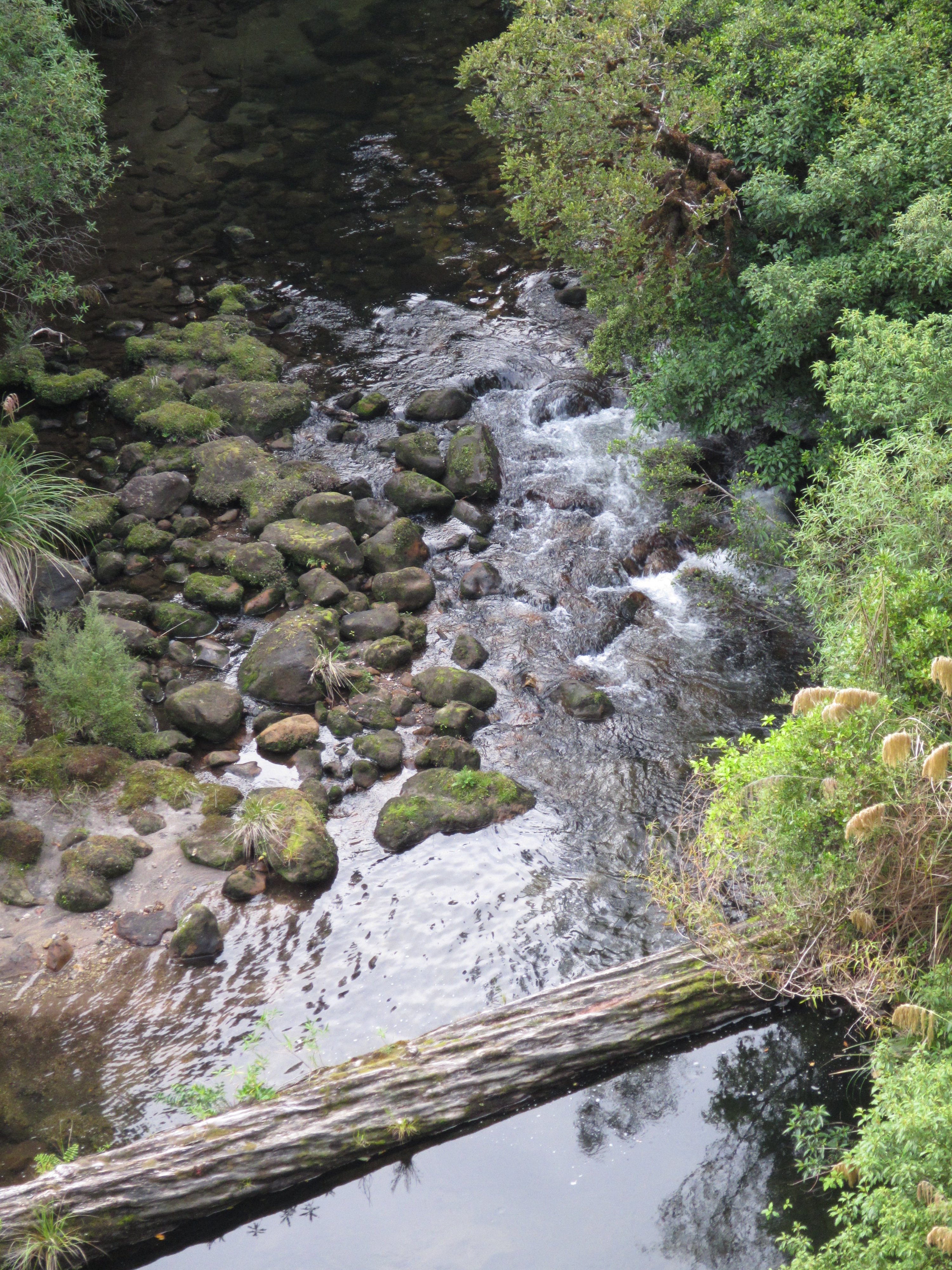
The numerous rapids if you can call them that, over 200 of them along the length of the river. Most were very tame. All class 1 and some class 2, with some tricky turns to avoids rocks in the middle of the rapid, log jams, submerged snags and fast currents trying to barrel you into the steap cliffs. I think we all had a turn at flipping our craft at least once along the way, chasing shoes down the river and emptying boats. At least the water was warm and the days hot and sunny, making for fast warming and drying off. Although on the first day it was raining and overcast and happened to be my turn to flip…right at the end of the day as we paddled to shore for the first nights camp. On exiting the water I was freezing, my hands turning blue. My first task was to strip off out of my wet clothes and change into dry thermals and water proofs. Needless to say my clothes didn’t dry overnight and I had to start the day in damp everything. From day 2 it was sunny all the way.

The huge cliff walls were another highlight. In many places sheer for 20m before easing off a little into high angled cliffs with vegetation. Many of the walls have what I kept calling hanging gardens, ferns, vines and epiphytes clinging to the rock in the most unlikely of places.

There was a lot of evidence of heavy rains and high water levels earlier in the year with the remains of major rock falls and slips littering the high walls, sweaping everything in their path into the water, leaving nothing but bare ground; and debris held aloft in the tree canopy lining the banks.

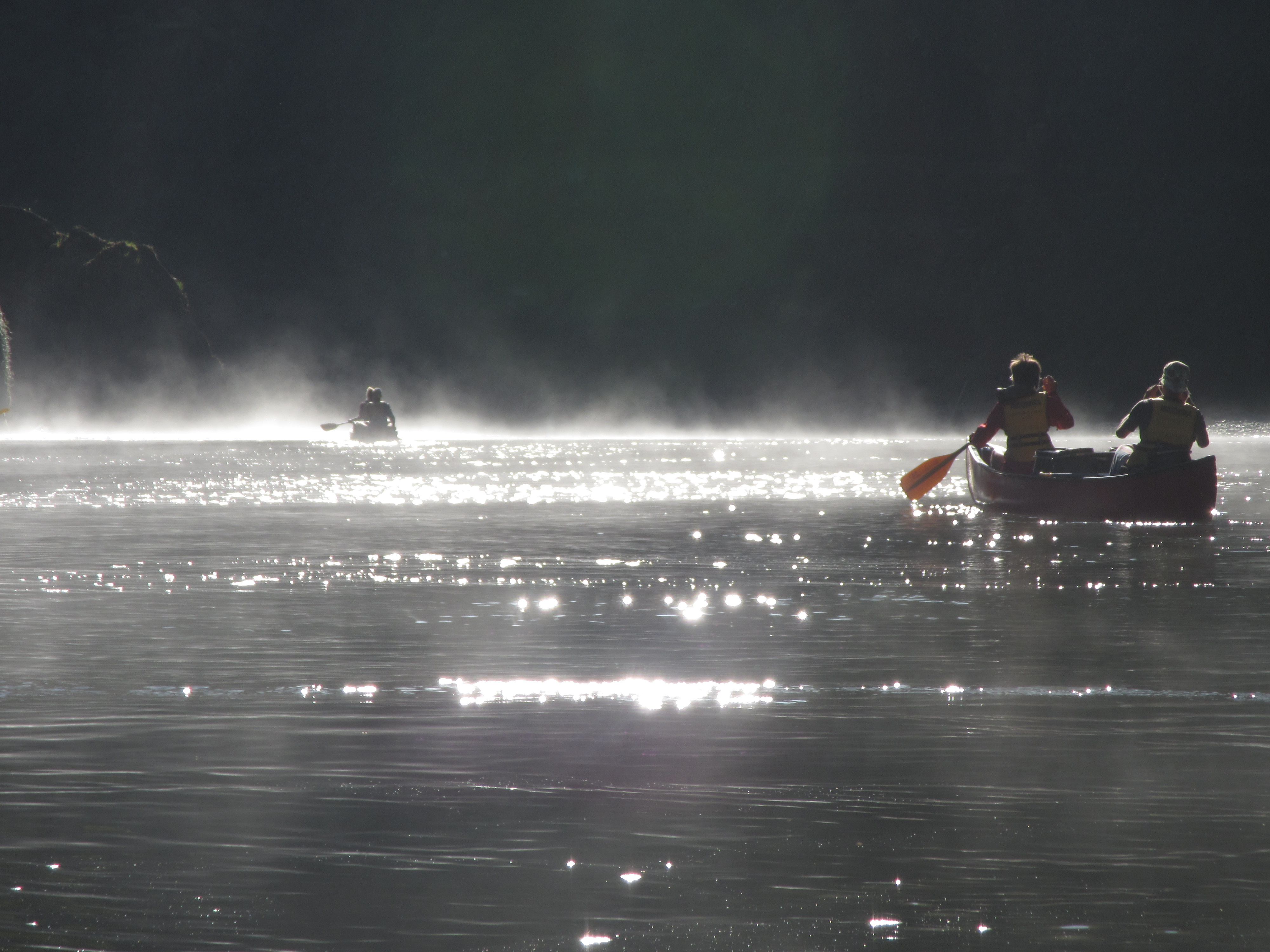
Early morning mists rising off the water were stunning. It made for an eary feeling but were beautiful with the sun light reflecting off the water and silhouetting the mists. A few times it made the path through the rapids difficult to see.

image

We opted to stay away from the major places most people stay at along the ricer, choosing the less used camping sites and it was well worth it. Quite a few times we had the place to ourselves. From what I heard most of the hut sites were jam packed everyday with up to 24 people sleeping in them.

image

Christmas day was one to remember. A perfect camp site with the perfect swimming hole to end a hot day while enjoying a beer or two. Christmas dinner was a backcountry feast of numerous delights that each of us brought along, capped with a shared bottle of wine.

The many creeks and rivers reaching the edge of the cliffs and showering down like rain or pouring out of the deep funnels they had carved into the soft sandstone overvtime.

Next time, and there will be a next time, I think I’ll opt to go only to Pipiriki and take a jet boat out. Below Pipiriki the rapids are fewer and far between although a little harder and the last day into Whangauni will be rembered as a very hard one. Towards the end the river is subject to the tidal flows and for the last 10 km we battled no only an incoming tide but the daily headwind which made for very slow going and tough paddling. It was great to get to the end.

Other highlights included dodging jet boats after the Bridge to Nowhere as they ferried day visitors in; the walk in to see the bridge itself; kingfishers diving for a feed and attacking larger birds of prey in the air, just to name a few. I’m sure I’ll think of many more to jot down.


Day 43: Taumarunui Zero Day

Distance travelled today: 0 km

Total TA distance coveted: 1003km

No travel today just relaxing and resupplied. 

I arranged an 8 day trip down the Whanganui River from Taumarunui to Whanganui starting tomorrow with other TA trampers. Should be a great trip with Chris, Cathi, Jurgen, Antoine and  Solenne. Looking forward to having Christmas on the river away from all the chaos associated with the 25th Dec these days. 
 

Day 42: TA kilometre 1033 to Taumarunui

Distance travelled today: 20km

Total TA distance covered: 1053km

Ha ha… in writing distance just then it came out dustance, which is probably how most kiwi’s would say it.

Today was basically just about making it to Taurmarunui and walking the remaining 20km along the road. I set the alarm early but decided a sleep in was called for once it went off. I slept really well on my bed of ferns fronds.

Packing up camp I saw the US crew of Princess, Disco and Skitles walk by along the road. If I was ready to go right then and there I would have called out and walked with them but I still had a bit to do and hadn’t finished breakfast.

I was on the road by 7am. My biggest concern for the day was water. Dry camping last night I needed what I had remaining for the 20km day ahead. I had about 500ml. There are numerous creeks running under the road through this section but they all run through farmland and I’m never prepared to drink from them.

As luck would have it, like on so many occasions on this trip, around 6 kilometres in I stumbled on Sam’s Shop. Sam is an eleven year old local kid that on seeing all these strange people wander past his house each day in summer, found that they were walking Te Araroa and came from all around the world. He was curious to know where they all came from and set about constructing his own trail magic water stop for the trampers. Sam has set up a stall out the house on the road side with a log book for trampers to record where they are from and offering fresh, clean drinking water and lollies for trampers. Perfect! Great job young man and very much appreciated by all the trampers who stop by.

image


imageContinuing on the road I caught up with the US crew as they took a break under the shade of a conifer tree and we played leap frog along the road for a bit.

We caught up again in town at the first establishment offering food. In this case I couldn’t have been more pleased. There is nothing wrong with scoffing a large pizza at 11am is there?

I then headed looking for accommodation for rhe night. Most trampers hole up in the holiday park but it is 3km out of town. I have a bounce box to pick up and a package with new shoes and really didn’t feel like continually running back and forth the 3km in/out of town. I opted for a cheap motel and they looked after me at TA rates for 2 nights. They even did my dirty, stinking laundry for free! The post office is a block to the left and the supermarket a block north. Cafes and takeaway galore close by. The perfect spot fir a rest day really.

With my bounce bix collected from the post, I didn’t muck around preparing for the next leg. It’s a few days off Christmas and I wanted to see if I could jump on board a kayak trip down the Whanganui River on Thursday, before everything shuts down over the weekend. I’ll find out tomorrow. For safety readons, the hire companies don’t hire to solo people but the company I called did have 2 other small group bookings departing on Thursday and they are going to make contact with them to see if they don’t mind a tag along. Basically if they don’t mind me tagging on, it means we start together but go at our own pace, i’d be in an individual kayak and we just have to meet up at the same place at the end of the day; that way the kayak company is covered insurance wise. All going well, there both groups of young Swedish backpacking girls named Inga. Yeah right. I wouldn’t know what to do. More than likely groups of oversees tourists at any rate.

Anyway, it if pays off it looks like Christmas on the Whanganui. Looking forward to being able to carry some heavier, decent food and beer in a kayak, giving my feet a rest for 5 days and letting my arms do the travelling. It should be around 145km of travel down the river, then I’ll yo-yo back north to do the Tongario Crossing.


Day 41: Waihaha Hut to TA km 1033

Distance travelled today: 30km

Total TA distance covered: 1033km

Based on the track notes or the DOC signs, today was expected to be a big day with at least 9 hours to walk 18km through the forest out to a road, followed by a full road walking section for another 37km or so out to Taumarunui. So was with this in mind that I set the alarm for 6am, aiming to be on the trail by 6:30am and to get as many kilometres in during the cool morning as possible. I had my pack, packed last night and basically just needed to throw my sleeping bag in, munch on some bars for breakfast and get going.

The Hoff had the same idea and was on the trail just before me but there was no in catching him. This guy moves fast, real fast. An ultralighter carrying very few kilos. Wish I could do the same but I’d say I’m light weight for this trip, not ultralight. I keep thinking of gear to ditch and am still finding stuff to send home or send ahead in my bounce box but I think my gear is as paired down as I’m prepared to go. I want to be comfortable on the trail. There is enough of a sufferfest walking big miles over hard ground, I want to be able to sleep well at the end of the day, be warm when I need to be and stay dry.

I hit the trail virtually running. Along the river the going was flat and really top quality trail. It made for fast and really enjoyable walking. I chewed the kilometres down.

Despite how I thought the trail would be with the description of 10 hours to the next hut, it was great. A few steep ups and downs and the odd wind thrown area to duck under or around, but for the most part easy going either following the river or thin ridge tops with great views down. The distance came easy.

image

Along the way I stumbled into a trail maintenance crew who had been choppered in to the next hut, Hauhungaroa Hut, and were working their way through. Turns out these guys had done the maintenance I’d walked through in previous days and were staying at the hut. What a job. I wouldn’t mind that. Walking through the forest with a mini chainsaw, clearing track and getting choppered in/out with food and beer. I quizzed them how far to Hauhungaroa Hut and they reckoned an hour and a half – for me this meant an hour.

Sure enough I arrived at Hauhungaroa just after an hour at 11am, taking 5.5 hours to reach it from Waihaha. Not sure how anyone thinks it might take 10 hours from hut to hut. Perhaps the trail notes are meaning 10 hours from Waihaha out to the road?

Anyway, based on this awesome effort, I realised I would not be staying at this hut tonight with still the best part of half a day to keep walking. At this rate I’d easily meet the road by mid day and might as well keep pushing as far as I could to reduce tomorrows 37km road bash down as far as possible.

DOC’s estimate from Hauhungaroa Hut out to the road was 2 hours so I set myself the goal of taking half an hour of it. But I couldn’t do it and it took me the full 2 hours. From Hauhungaroa the track condition deteriorated back to the typical tramping standard that I had come to know through previous forest sections. Back into roots and mud with with sone really steep sections thrown in where a rope would have been handy on the slippery mud; I made do with tree branches.

I reached the road by 1pm, found a nice shaded spot and got stuck into lunch. A nice long, shoes and socks of break was called for. Any additional distance from now was bonus as I thought I might be camping out near the road at the start of the day.

The rest of the afternoon was spent road bashing as many kilometres as possible. On my way out I met Ross a keen hunter with pack and rifle slung over his shoulder, headed high to one of the mant open clearings where he might chance a deer. We had a good solid chat fir 10 minutes or so and he wanted to hear all about Te Araroa. A firm handsake of congratulations for making 1000 kilometres and we were on our respective ways.

The road was long and just a little boring. This is remote farming land with very little traffic. This was great. I was able to walk ithe middle of the road where the crown is highest and listened to an audiobook of Alice in Wonderland on my ipod. The surrounding views were great and more than made up for the road walking. Prime agricultural land with lush green, rolling hills. A mix of sheet and cattle properties. Young steers are hilarious. Very curious creatures. Whenever I’m walking past they all rush the fence line to take a peak at yet more tramper trash heading through their patch and then follow along until they reach a corner fence blockading their way. Different from the diary cows who either immediately run off or remain competley unfazed and focused on the next mouthful of grass.

I after quite a few kilometres of metalled road I hit the bitumen. I pushed as far as my feet would carry but didn’t have anywhere to stay. I was going to knock on the next door I came to and ask to camp in a paddock but on approaching it looked a bit dodgy as and I moved past. Luckly not far on I came across an unfenced section of forest, indicating it was crownland. Jumping off the road and into the scrub I scouted for a flattish spot. With some fern fronds thrown down to level the ground I had the perfect site. Up high, hidden from view from the road I was finished for the day. Tent set up and bed laid out I then cooked dinner, a thousand different bird calls the backdrop as they also settled down for the night.


Day 40: Bog Inn Hut to Waihaha Hut

Distance travelled today: 17 km (8 hours)
Total TA distance covered: 1003km!!! 1/3 complete.

Can it get any better than this.

I could not believe it. A full day through forest and I have dry feet. I suspect it’s a change in geology and forest type that makes it this way. Looks like most of this forest has pumice under the top soil which allows the area to drain much better than just about all of the forests I have walk through to date.

From Bog Inn Hut I found the going to be really easy up to the summit of Weraroa. The hut sits at about 850 metres and the first 2.5 hours of the day followed a gentle rise along a ridge line to 1100 metres. The trail was well defined, easy to follow and make for a pleasant start to the day.

Descending down to the Waihora River it was much the same. A gentle climb. Some tiny sections of mud but easy going. I thoroughly enjoyed just taking my surroundings in, listening to the birds and enjoying the walking.

Two big surprises for today. The first coming across a trail marker indicating 1000km and 1/3 of Te Araroa complete based on the 2015 updated maps. Wow!! I’m using the 2014 maps and my 1000km mark is shown early tomorrow morning but I have followed the 2015 route for all but one section. So I’ll take it. 1000km. Holy shit that is awesome. 40days in and a good indication of my 120day estimate to complete the trail. But so long to go. 2000 smackeroos. It was a great feeling. Right there on the spot I launched into a silly dance. I pulled the gopro out but didn’t really know what to say and couldn’t repeat my impromptu dance moves, it wouldn’t have been the same.

image

The 2nd surprise was the descent and climb out of Mangatu Stream. All day it had been gentle climbs and rises along the way until approaching the stream. The ridgeline thinned right off to become very narrow and it looked like the way ahead disappeared straight down. It did. I would say from 20 metres up the trail descends down to river height over a a horizonal distance of 5 metres. Several vertical sections required careful climbing down using all limbs and grasping onto exposed roots. Once crossing the river over a fallen log the climb out was much the same, before getting back onto easier ground. From there it was onto the last 2km of the day to Waihaha Hut.

I got to the hut around 3:30pm and considered my options. Tomorrow is susposed to be big day with the track notes indicating 10 hours to the next hut, so I could keep pushing for a few more hours and find a spot to camp in the forest but I had no idea what the terrain would be like to find a flat spot. With 10 hours the stated time, sounds like sliw and steep going. Plus this would put me at the next hut tomorrow afternoon anyway where I’d have to make the assess the same options, to push on or stay. Arriving at the hut the DOC signs actually indicated a shorter day tomorrow, stating 12km or 7 hours to the next hut, not the 10 hours stated in the trail notes; and 18km or 9 hours out to the road end. In the end I decided to stay.

So an early afternoon it was. The sun was out and provided an opportunity to get some laundry done. I was really hot and tried to go for a swim in the river adjacent to the hut but that lasted all of about 1 minute before my legs went numb from the cold water. Just enough time to quickly dunk, splash down my sweaty body and get back into the sun to warm up and dry off. Then spend the afternoon catching up on writing my blog for the last couple of days and reading.

Late in the afternoon I was joined by Luke, shortly followed by The Princess of Darkness, Disco & Skitles and another TA tramper I was yet to meet called ‘The Hoff’ or Lewis from Australia.

Day 39: Benneydale to Bog Inn Hut

Distance travelled today: 20 km, plus 30 km hitch
Total TA distance covered: 985 km

Awesome day on some great trails.

I was packed up early as it Saturday and I didn’t know what the hitchng would be like from Benneydale. I didn’t need to worry. With the luxury of a cafe across the road I headed in for my second cooked breakfast in two days – you cant pass these opportunities up. Polishing off my coffee I headed back across the road to see if I could hitch.

As I got across a car pulled up and the fella started heading into the cafe. He saw me with my thumb out and called across that if I didn’t have a lift by the time he’d had a brew he would take me. Then he walked into the cafe momentarily before coming back out and calling over “Do you want a coffee?”. With my attitude of saying yes to opportunities on this trip I should have accepted but politely declined having just had a large, extra shot latte. He headed back in and the next car coming through pulled up offering a ride. Turns out my Maori driver grew up at Pureroa Village and was headed that way to meet his brother before attending his niece’s wedding in an couple of hours.

It was a lively drive, full of conversation. What a great guy, but I forgot his name…sorry pal. I heard all about the hungy they had just prepared, his family, the history the local area, his work as a faller for a logging crew, etc… It was basically a free tour of the area. He dropped me on the highway at my turn off and I was on my way for the 4km road walk to the start of the Timber Trail and the Pureroa Forest.

Today had to be one of my favourites to date. The weather was perfect, the trails were in great shape and I actually got to see some views from a mountain top. The timber trail is a major piece of infrastructure for the NZ mountain biking community and forms part a national cycle way. As such it was perfectly graded to allow bikes to easily climb high, making use of switchbacks and bridge over any stream crossings. It was perfectly groomed and made for fast walking. Each kilometre is also marked so it made it easy to assess my speed.

image

The timber trail climbed steadily through patches of native timber and the occasional patch of harvested private pine. It didn’t take long at all to walk the 16 kilometres or so to the turn off to Mount Pureroa. The mountain bike tracks skirts around the trig point but the Te Araroa follows up and over before getting back onto the TT.

image

From the trail junction it took another hour to reach to summit but boy what a view. Finally a summit that was not in cloud and a was actually on a clear, sunny day. At 1165m the trig point had a commanding and compete 360 degree view across Lame Taupo, Mount Ruapehu and the Kaimamawa Range. The perfect spot for lunch.

image

On top I had full reception and had a quick catch up on email. I managed to get in contact with Sarah who I work with and we are trying to tee up to meet just after New Years so she can join my for a section. Looking at my options for the trail, I’m considering heading straight down the Whanganui River from Taumarunui and see how far the hire companies will let me travel. Hopefully all the way to Whanganui. If this pays off I’ll meet Sarah in Palmerston North to take on the Tararua Range and then head back north to complete the Tongario Alpine Crossing. Thru hikers call this yo-yoing.

At the top I also met Luke, another TAer from the UK. I wanted linger up the top but with lunch done, the wind up and starting to get chilled it was time to get going. A 40 minutes descent and it was back onto the well groomed timber trail for a few more kilometres.

Finally the Te Araroa left the Timber Trail, heading south through forest for another couple of kilometres. As it was forest I was expecting another mud fest but was honestly surprised to find the trail in great condition. I’m sure if it was raining there would be mud patches but nothing to worry about today. Hitting a track junction that I would be back in tomorrow morning, I turned off for the 15 minute walk to the Bog Inn Hut to spend the night in the tiny 4 bunk DOC hut.

Luke joined me at the hut later that day, where we cooked up dinner outside and enjoyed intermittant conversation between reading our books.

image