
Distance travelled today: 28km
Total TA distance covered: 701km
Mixed bag today.
We got away with it. No-one came to check the park or even close the gates by the look of it. We had to wait until right on dark, just before 9pm to pitch tents. Even then there were still tourists coming into the park to view the falls. But after dark, all was good. No more tourists. We had the place to ourselves.
Falling to sleep with the sound of the falls rushing down in the back ground was easy. Can’t say that I’ve slept near a water fall before. The constant hum of the tumbling water was very similar wind blowing through the trees or the ocean surf without the crashing of big waves.
Easy going at first this morning, with the best constructed track I’ve walked on to date – go Auckland Council! Perfectly graded, climbing but easily and using the slope to switchback where necessary; great surface and well drained. Perfect way to start the day.

This all changed of course, as I’ve come to expect from the TA, as the trail turned off from the perfect track to a tramping standard track, to head towards the Wairoa Reservoir. This was a real mixed bag type of track with muddy, rooty sections at the start, some formed track and steps in the middle and everything in between.
The council really need to do a clean up run along this track though. Scattered right along are the remnants of track construction or maintenance materials – big bags used to sling in equipment by helicopter littered the track as did buckets and old tarpaulins.
I reached the dam by 11am and had a small break before continuing over the wall and up another well graded track to a repeater station and access road. At the end of the road a gate blocks access to vehicles. It was near enough to lunch time when I got here and smashed down some energy.
From here I had a decision to make. I was using last years maps and trail notes but did have access to the 2015 maps as well. Problem was both sets of maps do not match the trail notes or some of the directional arrows. I knew this and had researched a little before coming across to NZ. The 2015 maps follow several MTB tracks in the area while my 2014 maps showed the route heading along side pines in a direct southerly line to the junction of the Lower Mangatawhiri Track. Do I trust the maps and instructions I have researched; follow the arrows as displayed in the field or follow the 2015 maps without trail notes?
I was getting low on water and really needed a top up. Following the 2015 maps would bring me to the Mangatawhiri Lower Camp and water while the 2014 maps would keep my up high on ridgelines for the rest of the day, away from water. Staying high also committed me to completing another 10k before reaching a camp or water.
I went with what I knew and stuck to last years 2014 maps and trail notes. This turned out to be easily enough to follow. I was thinking without the traffic of this years walkers the route would be hard to see and I had no idea with the map updates if the trail markings had been altered or changed in the field. They hadn’t. Directional arrows were still in place. The only thing obscuring the track was an occasional tree over the track from recent harvesting adjacent to the track.

There was a solid forestry road just on the other side of a fenced that parallels the TA which would have made for easier walking but I never knew if the trail would divert from the road and so stayed on the marked trail. It was heavy going in places. Lots of out-sloped, sidle sections, rooty and much leaf cover. Luckily without the bulk of the 2015 tramping traffic coming this way it was mud free.
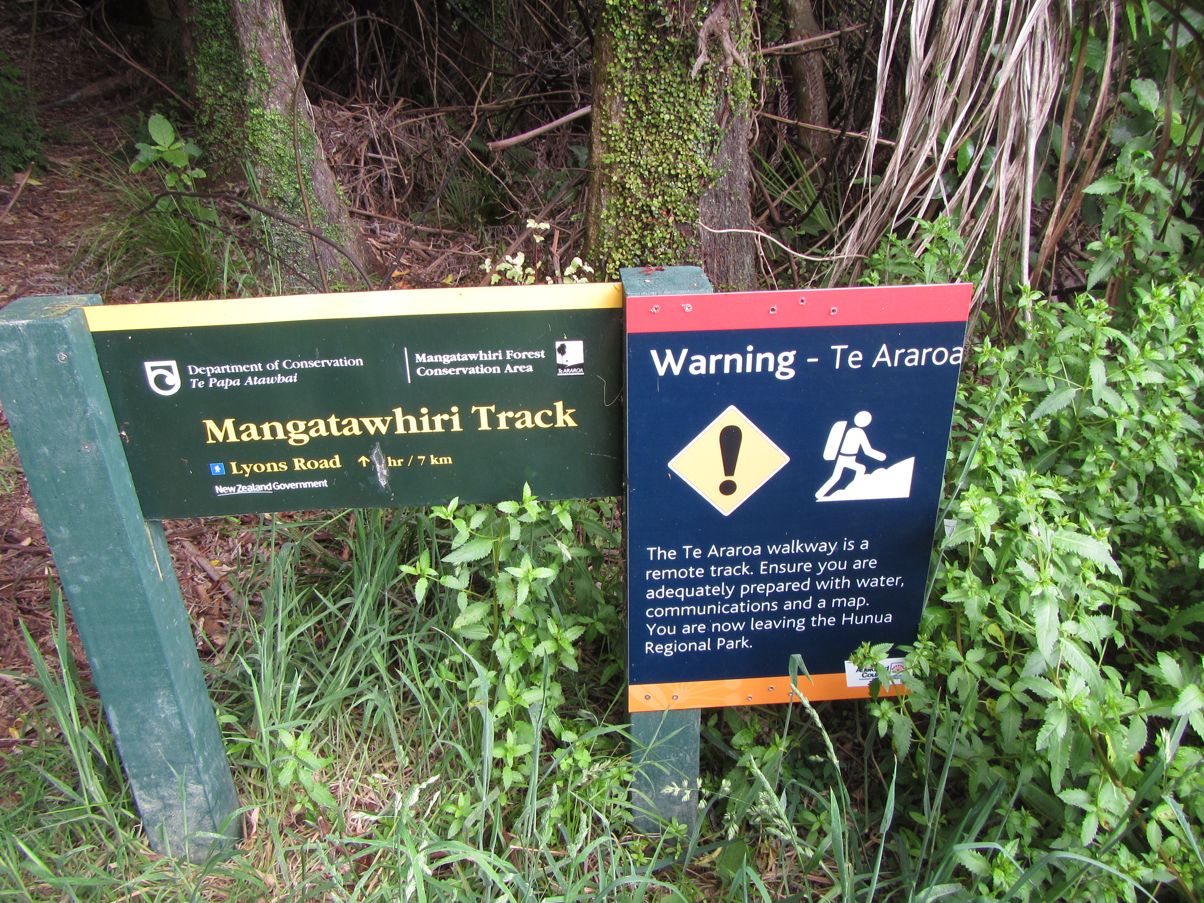
Up until now I had been moving through the forested sections all through the day relatively quickly, anywhere from 3km to 5km an hour. This was great and boosted my confidence for the next section, the Mangatawhiri Track. The sign at the start showed the distance to be 7km and I knew it was more like 5km to a camp site near a swing bridge towards the end of the track, but someone had scrubbed the time out. Distance isn’t always the best guide to travel time as it changes so much based on track condition, time is often the better guide for what to expect from the trail.
It was around 2:30pm. Based on todays walking speeds/times and my understanding of this being a tramping standard track, I estimated it should take 1.5 hours to cover the distance. Boy was I wrong. This turned out to be the longest 5km in memory, taking a full 3 and a bit hours. I can only describe this forest as a tangled mess. Vines and roots everywhere waiting to grab hold of you and keep you. This is more of a route than a trail or track of any description. Very steep in sections and really only orange markers and footprints to indicate the presence of a way through at all. To look off the trail is to look into an impenetrable jungle. Why anyone would place a trail here other than to link up the Te Araroa is beyond me. No-one in their right mind is tramping this section of bush as a day walk for recreation. It is only because of TA that it is walked.

Reaching the end of this section of trail couldn’t have come soon enough. It was much longer than anticipated and I was completely out of water, having rationed my 500ml over the last 3 hour stint. I knew there was a river at the bottom and I desperately needed to hydrate to replace the blood, sweat and tears lost and spilt across the Mangatawhiri Forest.
700km in, now thet tell us!!!
Just before 6pm I made it! Another very long day. Close to 11 hours of walking for not much distance really. 28km? Should have been able to smash out 30 plus with 11 hours. Not to worry. I expect a short day tomorrow, only 17km or so to Mercer and cold beer and pizza at Podges Place.
As I reached the end of the trail for today I came upon two other TAers camped by the swing bridge. Emma from Denmark and Jay McArthur from Canada who also has a blog publicised on the main TA web page. I mad contact with Jay before I left for the trail as we had start dates only a day apart but have only managed to catch him now.
Think I will sleep well tonight and hopefully be able to sleep in – problem is. I’m waking with the sun at the moment which is quite early.
Um…silly me. Just reading the track notes the Hunua Ranges are meant to take 1.5 days and are over 30km. Not sure where either piece of information has been sourced but I don’t think they are quite right. Today was long but not 30km and unless your standard tramping day is 6 hours then yes I will take 1.5 days but it’s easily done in a single long day.

mick beckers…….. u are an iron tramper!
LikeLike
loving the up-dates. Read them every morning before work. Becoming a ritual.
LikeLike