Day 87: Anne Hut to Boyle Village Outdoor Ed Centre

Distance travelled today: 28 km
Total TA distance covered: 2056 km

The way of St James

No I’m not in northern Spain and there are certainly not any nice little wineries, cheese makers or shops to sample tapas along the way; I’m still on Te Araroa but following the St James Walkway today all the way from Anne Hut to Boyle Village.

I was two days ahead of my arrangements with the Boyle Village Outdoor Education Centre to stay the night and collect a food parcel and I wasn’t sure what would be happening at the centre for the weekend. This is remote country and I had no way of contacting them. So my mission for today was to reach the Outdoor Ed Centre by 3pm, a time that I was fairly sure the centre would be open and probably in the process of winding down for the week. To get there by this hour though meant an early start for me. Up at 5:45am and on the trail by 6:30am.

Today was mostly a repeat of yesterday, just in a different direction and up a new valley. The trail was flat, well marked and travelled through tall grasses for most of the morning, following the Anne and Boyle Rivers. A wet feet start to the day again with multiple swampy areas and small creeks to cross. Added to that it was misty rain, clinging to the grass that then clung to my clothes.

I was flying along today and basically just ticking off features as I came to them. Several huts, several swing bridges, forested areas and grassy valleys. The track was unchanging for the most part, offering up fast walking on a nicely defined foot pad and benched track. There were undulations but hardly noticeable. No major ups or down today.

image

Crossing the Magdalen Swing Bridge the trail turned to the worst it had been for two days. Back into rocky and rooty ground under the canopy of the beech forest but I enjoyed the tree cover from the sun as it appeared in the afternoon.

I arrived in time and there were no worries. Food parcel collected and I’m able to stay tonight given there will be a caretaker on site. M

Not part of the food resupply

Not part of the food resupply

Day 86: TA km 2003 to Anne Hut

Distance travelled today: 25 km
Total TA distance covered: 2028 km

Easy day

It was warm overnight with a NW wind blowing and made for a very comfortable and rested sleep. Sandflies were still an issue in the morning. Even with shaking the tent door to disperse them, every time I was in or out of the door, at least 10 to 20 would find their way in. Urgh.

There really isnt a lot to write today.

The ground was flat all day following the Waiau River through open grassland areas and the occasional patch of bush on a defined foot pad. The walking was fast and easy walking down one valley for most of the day before reaching a junction and turning to the west to walk down another valley on a four wheel drive track for the most part. I had the ipod in today just to keep me entertained as I meandered along.

There were quite a few creek and river crossings along the way and it was not a dry feet day. Many crossings were just too wide to have dry foot placements right across. Initially I tried to keep my feet dry as I’d just washed one pair of socks this morning and had them drying on the outside of my pack and didnt want to get the 2nd pair wet. In the end I just had to suck it up and plunge in shoes and all for a crossing just above my knees. The sun was out again today and the wind up so I knew my washed pair of socks would be dried by days end.

The excitement for the day was crossing a long swing bridge in the strong winds and getting pushed around a bit. I made good time to Anne Hut, arriving just after 3 pm and thought about pushing on but decided on a shorter day. I’d got my 25km in and if all goes to plan should arrive at Boyle Village tomorrow, two days ahead of the date I set with the Outdoor Ed Centre to pick up my next food parcel. So there was no need to rush or push for bigger miles today. How to fill in time in an empty hut then? Have a cook up of the surplus food you’ve been carrying all week, knowing that there is a whole lot more to pick up tomorrow. I’ve completely over estimated how long it would take to do each section between food parcels by at least a day or two.

image

Day 85: Blue Lake Hut to TA km 2003

Distance travelled today: 17 km

Total TA distance covered: 2003 km!!!

The big 2000!! 2/3 of the way there.

Leisurely start from Blue Lake Hut. I was treated like a rock star last night for what ever reason. The hut was full of section hikers and day trippers and they had never me anyone attempting to complete the full Te Araroa. Really? There are so many off us this year. Anyway, I lapped it up. I don’t mind being the centre of attention but so many questions that I’ve been asked a thousand times already. What do you eat? How many kilometres do you walk each day? What brand is your tent? Etc…. Thats all good though. I’m happy to answer the same stuff over. The more people we can collectively get to dream big and make things happen the better I reckon. One perk of being the big Te Araroa walker in amongst people only out for a few days is the lavish array of food given to you and my luck this morning, half 2/3rd of a bottle of red wine in a plastic bottle – to celebrate my reaching 2000km today and the 2/3rd point on the trail. No arguments from me. I was looking forward to it later today.

It was a quick climb up to Lake Constance with views back down towards Blue Lake. But then it took longer than expected to get around the lake and up towards the head of the valley for the long climb to the Waiau Pass. Getting to the end of the lake I could fully appreciate the climb up the scree slope to the pass for the first time. It just seemed to go up and up and up. It was going to be a long, slow climb and I had a short break before the ascent.

image

Then it was time. I had to get on the scree and start making my way up. I wasnt going to get there sitting on my arse looking up at the thing.

With one slow step in front of the other I started the climb. Initially on larger rocks that had accumulated at the bottom of the slope, having tumbled down at some point in the past. But then the trail moved just off to the side of the main scree slope which was a relief. Although there was definitely a section higher up that crossed across it as you could see the defined foot pad from previous walkers from below.

Slow and steady. Up and up. One foot in front of the other. Walking poles shortened to act more like ice axes, planting into the higher ground above and using them to leverage my body weight up slope.

image

Around half way I saw two people descending. We met and talked briefly. From France, the couple are walking Te Araroa NOBO and it’s taken them 6 weeks to get to this point. Thats encouraging for me. I’m a bit concerned about the time it will take to complete this adventure, wanting at least a 2 week transition back to normality before heading back to work, rather than finishing and going straight into the thick of ordinary life again.

image

We parted and I continued, up onto the scree itself. Lots of tiny loose gravel. At some points it was a case of one step forward, two steps back. Taking my time I minimised the my slips and reached the top of the scree ok. The route then continued over some more solid ground and across larger rocks. Moving up and onto the final scree slope to the top of the pass I meet a Kiwi section tramper coming down. Pleasantries exchanged we moved on and I spied the top, marked by a large cairn. On reaching it, I let out a holler before realising there were people coming my way from the other side. A group of school leavers having just finished year 12 and out to enjoy the final weeks before uni. They thought my trip was awesome as well and were surprised I didnt cheer harder on reaching the top of the Waiau Pass. They also had a thousand questions and we shared morning tea as I answered them as best I could. I was also shouted to chocolate, thank you very much guys.

image

Heading down was fine to start with, over rocky but solid ground. An up coming section is talked about quite a lot in the track notes, on blogs etc… as the hardest section in Te Araroa. More of a rock climb than walking I was lead to believe. The build up was palpable as I’d heard so much about it and I was looking forward to see what the trail could throw at me. On reaching the top of a steeper section I wasnt quite sure if this was the spot or not. It looked steep and there would be short sections to down climb using all four limbs but was it didn’t look too bad at all, at least not in comparison to similar sections I’ve walked through in SW Tas. Perhaps there was another spot further on that was the really hard stuff. I got down in no time with little hassle and it was only when looking back up that I recognised that this was in deed the hard section, I’d seen countless images looking up the face on other blogs where some had described their descent as terrifying. I have no wish to big note myself or sat it was really easy but this section doesnt deserve the attention, or being singled out, in the track notes. There have been countless more dodgy sections on the trail. I think if the terrain is steep, trampers are going to take their time to get down safely anyway and the reputation built up around this single feature is not justified. The knee jerking descent all the way to the bottom, some 600 m is more of a danger.

image

Slowly but surely I made my way down to the bottom and the twin rivers junction. I found a nice spot to prop for lunch by the river and enjoyed the new views looking up into new valleys. It was while sitting quietly eating lunch and just observing my surrounds that I had intense feeling of happiness overcame me. Sitting outside, surrounded by towering mountains, winter snow still trapped in narrow south facing chutes; sitting next to a mountain river, the sun out and shinning brightly. It was perfect. It will be hard to go back to work after this trip and settle back into the ordinary. If anyone knows the answer to how I can sustain this current lifestyle please share it with me.

Following the Waiau River down stream I passed a series of water falls. Long tendrils of foaming white water, cascading down between boulders to bright clear blue plunge pools below. I saw the perfect waterfall shower spot but unfortunately it was too difficult to reach. I’m determined to have at least one wash under a waterfall on this trip.

The trail moved from the open valley with alpine scrub and grasses back into the tree line and continued to follow the river. There were a series of avalanche debris areas that had to be crossed which I found frustrating. Adding the distances up thete would have been more than a kilometre of the stuff to walk across. I find them incredibly difficult as the foot placements constantly shift and threaten to twist ankles. It’s easier to rock hop or walk on top of the larger boulders that aren’t likely to shift but that is not always possible, and sometimes they do shift. Slow and steady again to avoid injury. Finally, trough the last debris field the trail turned into something more resembling a trail and made for quicker walking.

Moving down the valley, never far from the rivers edge and occasionally in the river where sections of trail had been washed away, the valley broadened as I approached Caroline Bivvy, to reveal larger grassland areas. There wasn’t much to Caroline Bivvy, a two person emergency shelter, no windows and collapsing bunks. And the sandflies were horrific. I pressed on for another 3 kilometres and found a sheltered spot in amongst old gnarled beech trees, over looking the river from a high bank. Perfect that would do me for the night. Oh yeah, just after Caroline Biv I passed 2000 kilometres. Wow!!!

I was a rush to get the tent up and all my gear inside as the sandflies were the thickest I’ve seen to date. Swarms of the little buggers. I hate the fact that something so small can so easily ruin paradise.

Day 84: John Tait Hut to Blue Lake Hut

Distance travelled today: 21 km

Total TA distance covered: 1986 km

Into the mountains

No fixed plan today. The target was either West Sabine Hut and then see how I felt to possibly move onto Blue Lake Hut. Today was going to be full of big climbing up and straight back down as the trail climbed from one valley overva high mountain pass and all the way to the bottom of the valley on the other side.

I got away from John Tait Hut just around 7:30am allowing myself plenty of time for today. From the hut, the trail continued on the banks of the Travers River much the same as yesterday. The soft whispering of the water was never far away, if not from the Travers itself, then from the numerous small creeks gently running across the trail, draining into the main river.

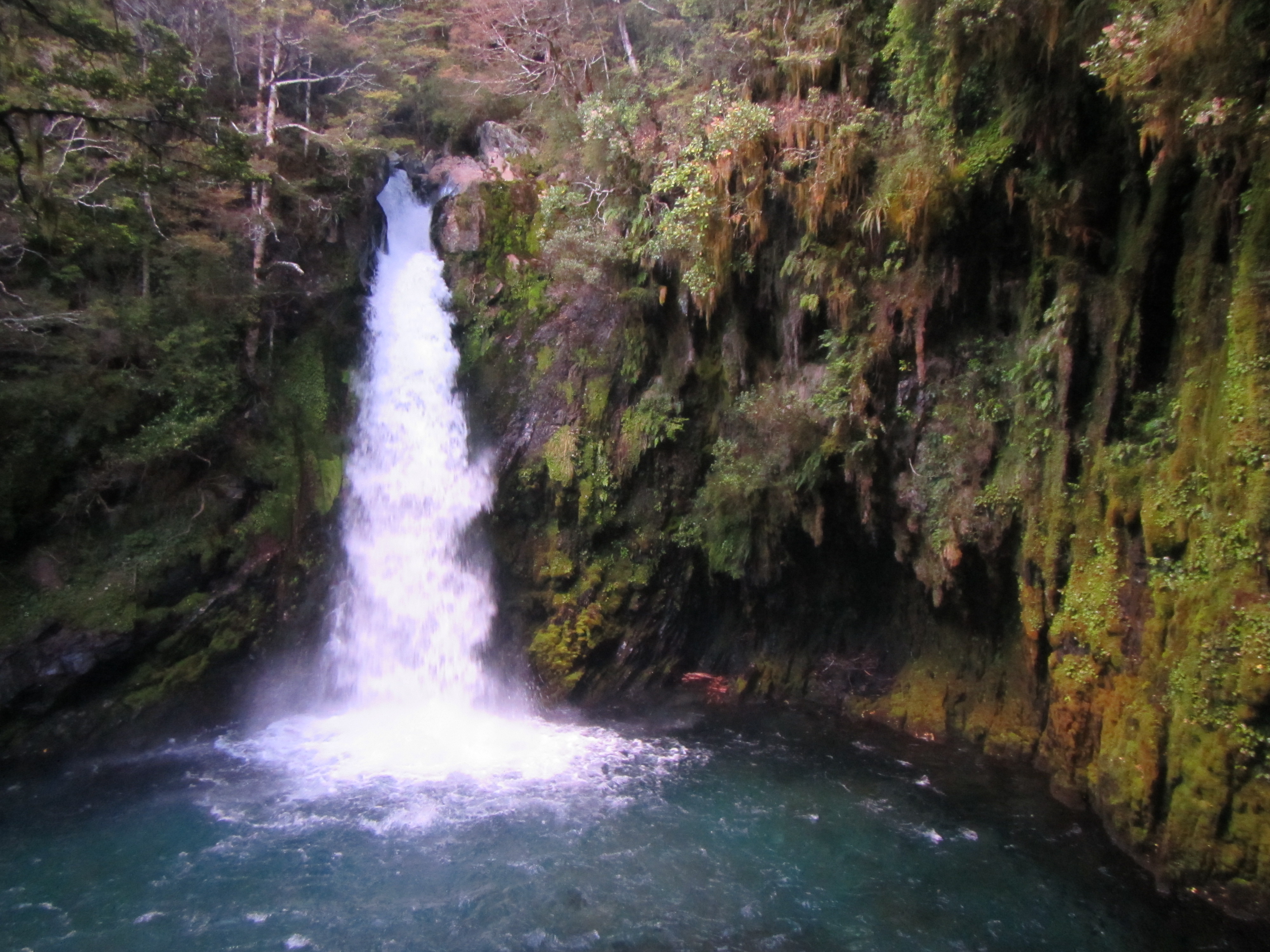
Around 40 minutes I hit the short side trail to the Travers Falls. Dropping my pack at the track junction, I followed the steep track, climbing down vertical sections of tree roots to the base of the falls. Spectacular! In a dark sided chasm the tumultuous waters of the Travers spilled down a narrow chute with boulders on either side, to a deep blue pool below. The amphitheatre of rock surrounding, bright green with moss and lichens climbing vertically yo the walls.

image

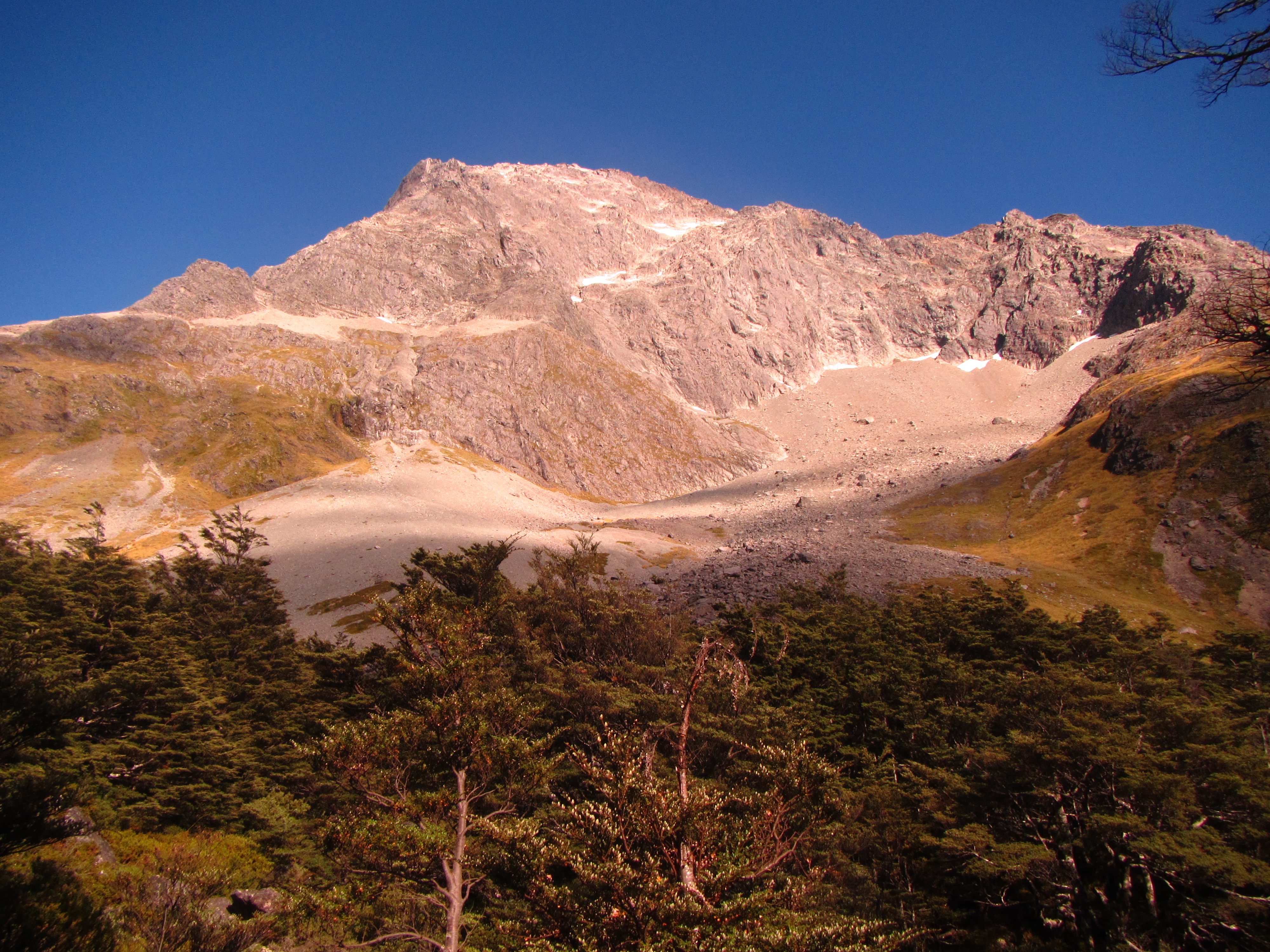
Further up the valley the first glimpses of the mountains lining the valley came into view through gaps in the trees. Talk about feeling insignificant. The eastern slopes of Mt Travers towering above at over 2000 metres. Vast slopes of bare rock and old avalanches ran down to the river with the odd water fall tumbling for more than 300m down.

image

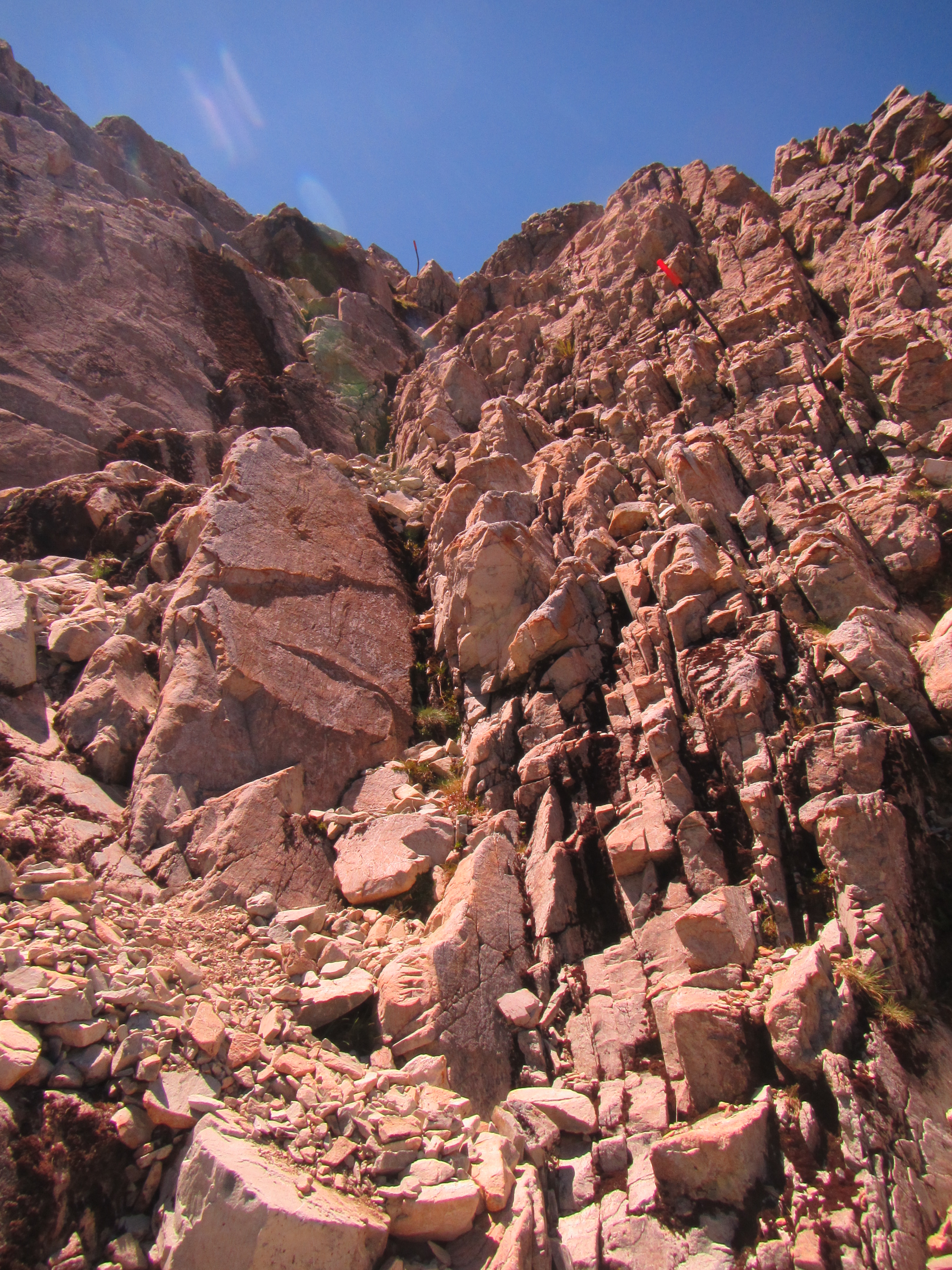
It was a hot day and the sun was starting to bite as it spilled into the valley as it rose over the peaks to the east. I continued towards Upper Travers Hut, running into the odd sign stating “avalanche danger – no stopping” and judging from the boulders spread amongst the trees I’d hate to be in the path of one of these beasts. Several sections of the trail looked like dry creek beds in amongst the trees but these were the tail end of narrow rock slides that had tumbled down from high, leaving a long trailing line of rock all the way to the bottom. Other sections were completely bare, having barrelled over trees to the river with little vegetation yet to reestablish itself. Random odd boulders were scattered through the scrub as well – their origin,way up high off the cliff tops. Get out of the way if these suckers come through.

image


I made it Upper Travers Hut in a little over 2 hours and stopped for a hobbit style second breakfast and apply sunscreen. Mt Travers now in clear and full view, dominating the horizon at 2337m. Snow still clinging to several shaded chutes on the south side.

image

From Upper Travers Hut it was 450 m up, to ascend the ridge line and cross over the Travers Saddle. Several section hikers were just starting their day and I followed them up towards the Saddle. It was a steep climb with a few rock scrambles but nothing of major difficulty or terrain that I hadn’t encountered elsewhere on the TA already.

On reaching the saddle, the views were spectacular. 360 degrees right around. It was so peaceful I had to sit up there for a good half an hour just to take it all in. A light breeze blew up and over the pass which was great to me cool down but when it settled and the noise of the wind left my years – absolute silence! Nothing. Amazing.

image

One of the section hiker who I met at the hut also at the saddle and a second who I passed on the way arrived soon after. It was great to share the experience with others and take in the vistas.

From the saddle, the trail lead straight back down the other side towards the Sabine River. Very steep descent and slow going. Across several more avalanche zones and very steeply down a scree slope for 1.5 km. This was difficult on the knees and my walking poles saved many a slide down on the loose gravel. At the bottom it was time for lunch.

The trail continued on the right bank of the Sabine River East Branch for a while before crossing over a short bridge to the other side. Deep below the bridge in a dark chasm the river waters rushed through. Easily over 100m down the rivers noise was muffled to a soft hum.

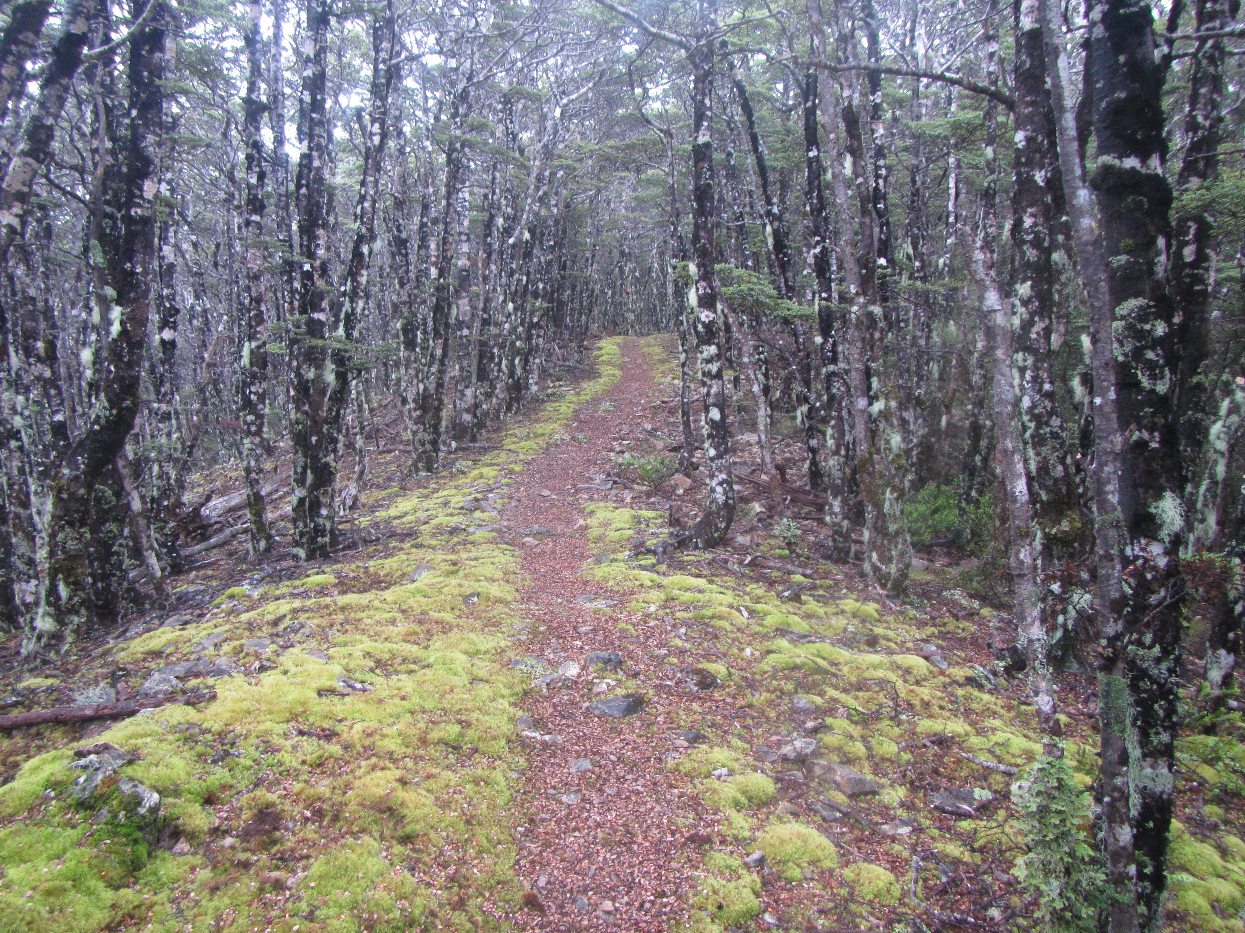
It was then into a sidle trail for several kilometres over roots, rocks and a few creeks before another steep descent to the Sabine River West Branch and West Sabine Hut only a few hundred metres away. I seem to be constantly eating at the moment and chomped down half of packet of Oreos at the hut. Water was plentiful right along the trail and I was drinking frequently but nothing like my hard day in the Richmond Range. It was 2:30pm and I decided I had plenty of time to continue for another 3 hours up to Blue Lake Hut.

From West Sabine I had to cross a swing bridge straight away and continued on similar trail already encountered. Some flat sections, some rock, some scree. It was up all the way to the head of the valley and the source of the Sabine River, not not really steep until the very end. I came across quite a few section hikers heading back down from Blue Lake and kept getting updates on how long it should take. 2 hours, 1 hour, 20 minutes. The final push was quite a slog for me given how far I’d travelled today. The last 1000m to the hut had some really steep sections and was slow going.

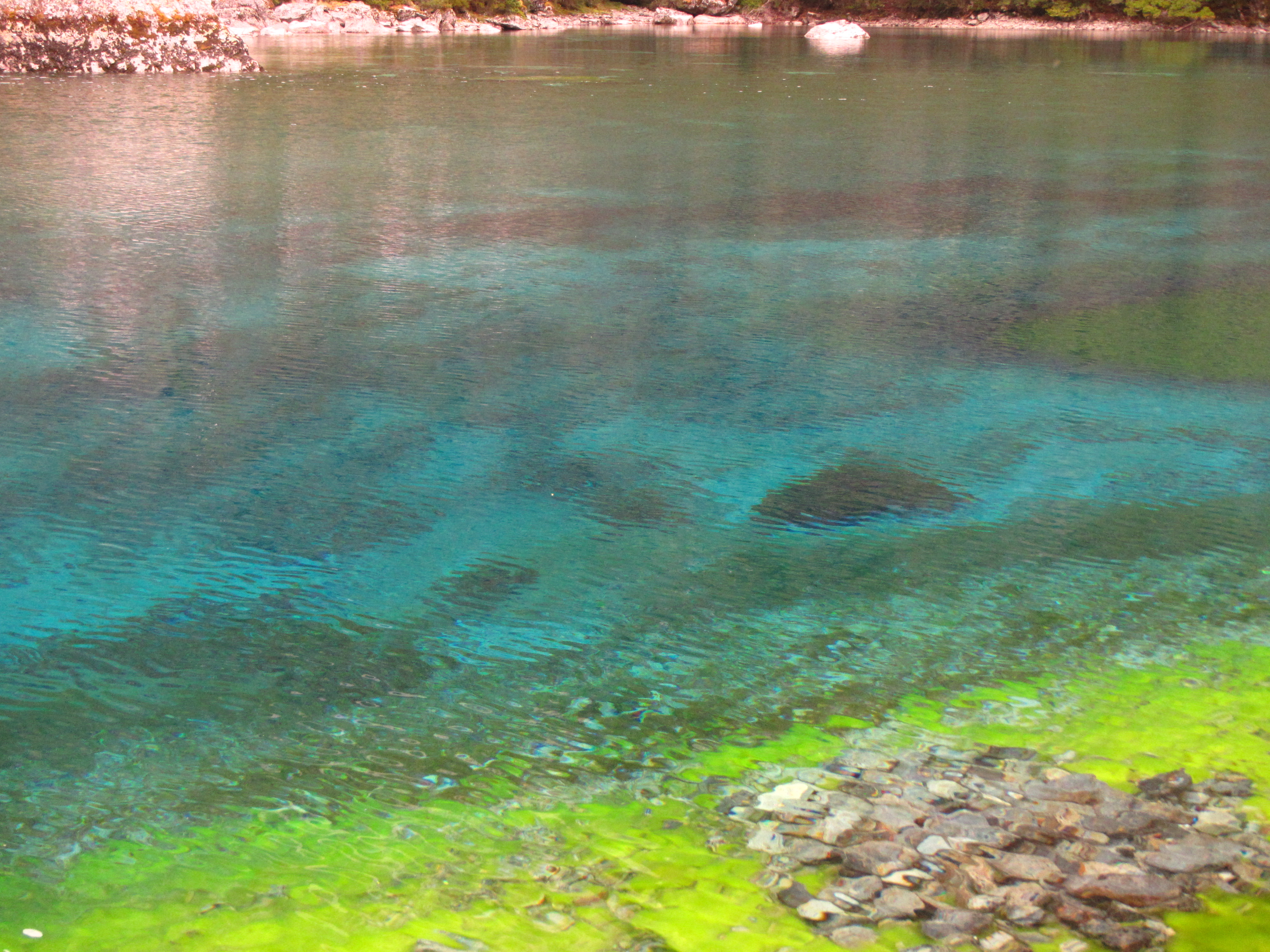
Glade to arrive and put and end to the day. Blue Lake itself was close by to the hut but unfortunately, or should that fortunately, swimming in the lake is not allowed. I would have loved a refreshing dip but the waters of Blue Lake are reputedly to be the clearest fresh water in the world, only exceeded in optical purity by the waters of South Pacific Gyre near Rapanui (Easter Island). The rich, vivid blues and the aqua of the water were a sight to behold, contrasted with the bright green algae growing within and the sheer walls of Mt Franklin rising above. I wonder if this is where the bottled water company Mt Franklin came up with their sales pitch. The waters are sacred to the Ngati Apa tupuna ancestral owners and to maintain the health,ecology and purity of the water, swimming is banned. So it was I had to settle for a water bottle shower to wash the days grime away.

image

A big day and bigger than most people typically do in these hills but it sets me up well to get over the Waipu Pass first thing tomorrow in the excellent sunny weather while it lasts. The Waipu Pass is the most difficult feature on the Te Araroa and requires good weather. By heading this far up the valley today I’ve also gained an extra day which is great.

I read in the hut book that McKayla, aka Hokey, is off trail having walked out back to St Arnaud due to knee pain two days ago. If you’re reading this Hokey, I’m truly sorry to hear that and hope you can get it sorted and get back on trail soon. All the best.

Day 83: St Arnaud to John Tait Hut

Distance travelled today: 24 km

Total TA distance covered: 1965 km

A bit of everything.

After a nice big breakfast at the lodge with lots of fruit, yoghurt, toast and croissants with Sven and Catherine I hit the trail. A latish start for me not getting away until around 9am but the first half of the day was mostly flat and straight forward. I’d walked the first 15 km previously on a part circuit on the Travers-Sabine a few years ago and it was familiar ground. The trail from St Arnaud to Lakehead Hut is very popular with day trippers and was a good quality track. Flat, wide and gravelled for good chunks, with the odd sections a bit wet with water seeping from banks and following the line of least resistance, which happens to be the track.

I made it Lakehead Hut in just over 2 hours having followed the track right around one side of Lake Rotoiti. I normally stop at every hut and sign into the intentions book but with 3 toilets outside this hut I knew it was heavily visited and the hut book would be full of trashy writing, written by day trippers. I’d previously stayed at this hut as well and had a good idea of what the hut book would be like so moved on.

From Lakehead hut the trail moved away from the lake, into grasslands up the narrowly valley. Tall peaks crowding the edges of the valley and rising 1000m straight up. The walking was fast on the flat grasslands and I pressed on a few kilometres until the track crossed a dry river bed and moved into the trees. I pulled up under the shade of a beech tree in the river bed and had a bite to each for lunch.

Moving on a few more kilometres the sound of fast rushing waters of the Travers River increased as I got closer and the trail crossed over the river on a swing bridge. All this ground was familiar to me but would move into new terrain on the opposite side.

The trail gave up a bit of everything as it lead south, working its way up the valley following the edge of the Travers River. From flat, beech leaf covered sections of the highest quality; to rooty sections; to dry shingle river beds; sidles with steep drops; and scrambles of old avalanches, the variety of the trail kept things interesting. It crossed the river itself a couple of times but all on sturdy bridges.

I reached John Tait Hut in the early afternoon and decided I’d done enough today.

Day 82: St Arnaud Zero Day

Distance travelled today: 0 km

Total TA distance covered: 1941 km

Unplanned rest day.

I had expected the section between Pelorus River and St Arnaud to take 7 to 8 days but found myself ahead of schedule and arriving in St Arnaud only after 6 days. My natural walking pace is fairly quick and I’m certainly not rushing through the trail, still I was surprised to get into town in 6 days, particularly given that one day in the mountains was really just a half day with a rainy start. So ahead of schedule and after a hard 35km yesterday I decided to take a day off and regroup. I have a food parcel here that I sent ahead to the Alpine Lodge and I get a chance to do some laundry and eat some delicious food.

image


Day 81: Hunters Hut to St Arnaud

Distance covered today: 35 km

Total TA distance covered: 1941 km

Going through the motions.

Today was really just a day of going through the motions of life on Te Araroa. A day of waking up, shouldering my pack and walking through the mountains towards St Arnaud. There was nothing really speclatular to write about today. Just rocks, scree and lots of climbing up then back down.

Continuing through similar terrain as yesterday I was starting to get sick of this portion. Sure it was great to be outdoors and not sitting behind a desk but there was little change in the trail and boring. From the start the trail was straight over the top of yet more jumbles of rock and boulders. With each foot step, feet were at irregular angles and it was difficult on the ankles.

The trail passed over yet more scree, slately slopes, traversed whole hill sides of gravel and passed through the occasional swampy area.

image

I reached Porters Hut in 2.5 hours (DOC time = 4 hours) and was glade I stayed at Hunters last night insetead of pushing on. Porters was not that welcoming, on the edge of a clearing with few views and not the best water source.

Fom Porters the trail cut a path along the top of a really steep bank overlooking the Lowther Creek about 100m below. The footing was fine and it would have been difficult to fall but if you did fall I doubt you would stop until the bottom. Before long the trail wound steeply down to the river itself which had to be crossed. The wide river valley filed with boulders, rock and gravel. A myriad braids of water cutting their way through. I found a dry crossing by hopping from rock to rock over the blue crystal clear water.

The trail then climbed up through a gravel creek bed towards a small saddle. Some scrambling through was required up steep banks of gravel, trying not to cause an avalanche under my feet.

It was briefly back into the trees and away from the rock but all too shortly lived before leading back onto the rocky path and steeply down a thin ridge to the Motueka River. The trail traversed high above the river for much of the day, offering clear views right up the valley.

I really liked the traverse trail. It was a sidle track but pleasant and made for fast walking. On reaching each smaller creek feeding into the main river the trail climbed down to cross before ascending again but the grades were fairly good. Each feeder creek was easily crossed while keeping shoes dry. After 3 km the Motueka itself had to be crossed. It was wide and fast flowing and I couldn’t find enough boulders for a dry feet crossing. On each side there were enough boulders to make it to the middle with dry feet but nothing in the main channel to bridge the gap. So it was shoes off for this one. I’d kept my feet dry all day and didn’t want to get them wet for one crossing. It wasn’t too bad. Flat rocks on the bottom made it easy on bare feet.

image

Across the other side and with feet dried I had to climb around 200m above the river back to where the trail cuts a traverse across slope high above the river again. Climbing was slow in the baking sun and once on top it was 4.5km of traversing to Red Hills hut. The pace was quick again on this trail. Towards the very end near Red Hills Hut it passed through more areas of swampy ground and after keeping my feet dry the inevitable happened, a pool of black water hidden beneath tussocks caught my feet and saturated them – damn.

I reached Red Hills just after 1:30p m and had a quick lunch but was keen to make it town still 16 km away and didn’t hang about long. Bashing down an old 4WD track for 6 km I reached State Hwy 63 in an hour. I thought about hitching the last 10 km into town but the road was twisty and turning with no where really for cars to pull off safety, particularly when they are at full speed on the main road. There wasnt much traffic anyway so rather than wait for a ride I hoofed it into town on foot, reaching St Arnaud at 5:30pm.

Day 80: Mid Wairoa Hut to Hunters Hut

Distance travelled today: 17 km

Total TA distance covered: 1906 km

What a contrast.

Today was awesome. It was to start with another sidle section from Hunters Hut, following the Wairoa River Left Branch for the whole morning to Top Wairoa Hut, and I was expecting it to be a tough start to the day but it didn’t turn out too bad. Initially the trail climbed high away from the river to avoid a cliff line but soon brought me back to the river. It was undulating along the river and necessary for the trail to climb up and down to avoid some treacherous features what would have been impossible to get around. It was a true sidle track to begin with, narrow, less than a foot wide, and some rock scrambles to get over with major drop offs to the river below. One section had a steel cable installed as a hand rail to keep trampers on the trail.

The trail soon returned to the river and required multiple crossings as it switched sides of the river to find the flat ground and avoid cliff lines. Wairoa River is a moderate sized river with fast running water and heaps of small waterfalls churning down through rock chutes and large drop offs. There were no dry feet crossings to be had today with the river being wide enough to not allow the accumulation of stepping stone rocks in the middle. In flood this thing would be enormous and I can imagine the water easily moving massive boulders in should conditions. Today the water level was low and all crossings were easy enough to negotiate. The deepest crossing was just above my knees. I keep my shoes on for such crossings as you loose quite a bit of time constantly changing into sandals and shoes allow for safer foot placement and toe protection.

It was beautiful along the river. So many photo opportunities and stunning features.

Around an hour before reaching Top Wairoa Hut I bumped into two TA trampers heading north or NOBO. This first NOBO’s I’ve come across and the start of many more to come. We stopped and chatted for a few minutes outlining to trail ahead for each other. For me there were a few more river crossings and one feature the track notes pay particular attention to: a rock chute to climb around that sits above a 4m waterfall. The trail notes simply stating it could be tricky and if you loose your footing you go over the edge. Turns out this isn’t even worth mentioning in the trail notes and proved no more challenging than many other obstacles encountered already.

imageimage

Can you see the trail marker on the other side?

Can you see the trail marker on the other side?

With the final crossings completed, the trail continued to climb, following the river upstream and out of the forest. Exiting the trees the surrounds completely changes. I’d been walking through beech forest and alpine passes for the past 4 days and was now looking at a landscape that wouldn’t be out of place in the outback. Red iron rich rock everywhere, stunted trees, grasses and teatree, and looking very dry. Whole hill sides were just rock.

I stopped  briefly at Top Wairoa Hut for morning tea and continued on. I had to climb high for the next few kilometres to get back up to another alpine ridge. From the hut the trail was basically on top of the rock itself for just about the whole way, scrambling over the tangled junble of rock. I’m not sure what sort of rock it was but it was grippy which was good, not only for shoe traction but it stopped the rocks slipping passed each other and moving like smooth river rocks do.

On reaching the ridgeline I was treated to clear views for 360 degrees around but some misty cloud was hanging around the higher peaks. As I followed the ridge line the trail traversed across a slatey scree slope to avoid one peak and the mist started to come in. The route was marked by poles and was easy to follow for the most part. A few times I had to sit put and wait for the mist to clear to locate the next pole and move on.

From the highest point, Mt Ellis, sitting at 1615m, the trail continued on rocky ground and scree steeply down to the left branch of the Motueka River. Hunters Hut was obvious sitting on a ridgeline in the distance but was still some 4km away and would take another hour to reach. I had my sights set on reaching Porters Hut today but my cut off time of 3pm to reach Hunters Hut was fast approaching.

Following the river towards Hunters the trail continued on rock, scree and the odd swampy section thick with tea tree. There were large areas of bright green and black rock glittering in the sun. I’m not quite sure what type if rock it was, hopefully someone can help me out. I don’t think it was greenstone as it was too flakey and was like tightly packed sheets similar to mica. Anyway, seveal large banks of the stuff looked awesome in the sun. I came across a Weta on the trail as well. These insects, similar to grass hoppers I guess, are massive, the size of my palm.

image

I was lead to beleive there was no water at Hunters Hut and on reaching the last river crossing before getting to the hut I had a decision. Fill up water at the river and stay at Hunters or continue onto Porters Hut and fill up on the way, thus avoiding carrying excess weight. I was still determined to continue onto Porters and pressed on but after the final climb upto the ridgeline where Hunters Hut was located I was buggered and decided I’d stay put for the night. It was close to 3:30pm and passed my cut of time. Porters was still 4 DOC hours away and I couldn’t be bothered continuing on. The scrambling over rock all day had taken its toll and I was feeling knackered.

But it turns out staying put was a great decision. The hut sits high above the river with commanding views right around. There was a full water tank, so that that was no worries and the hut was one of my favourites to date. Clean, tidy, lots of windows, afternoon sunlight right through and I had the place to myself. Perfect.

With a lazy afternoon, my first in a while, I lounged about, hydrating and reading the final chapters of Game of Thrones Book 3 part 1. I was treated to an amazing sunset as well with the red mountain glow covering the higher peaks.

image


Day 79: Rintoul Hut to Mid Wairoa Hut

Distance travelled today: 15 km
Total TA distance covered: 1889

Rainy start to the day.

It rained heavily overnight and into the morning. On waking I hear both wind and rain buffeting the hut and rolled over to sleep in. The next section from Rintoul Hut passes over another exposed alpine peak and there was no way I was doing this in the rain.

A lazy morning was had, resting, staying warm in the sleeping bag and eating food. Given that the hut directly overlooked Nelson I had full service on my ipad and was able to check the weather. The forecast and rain radar both indicating the rain was to break up around noon and there might be a chance to get half a days walking in.

The forecast was spot on. Just before 12pm the cloud started to break up and the views out from the hut towards the coast returned and the rain had all but cleared. I had my gear packed and ready to go and hit the trail.

From Rintoul Hut the trail ascended through similar beech forest that had been encountered in previous days, leading up to the treeline towards Purple Top. This exposed peak of 1400m I guess getting its name from the colour of the rocks on the surface. Many shades of purple, orange and red rock in loose shales forming an outcrop with very little growing. The route was marked with orange poles given there was nothing to affix the standard orange triangles to and with misty cloud coming and going over the top I’d have to look ahead at the next few markers to gauge the way before it disappeared into the cloud again. It didnt take long to get to the top. From there it was a matter of following the poles and walking over a large boulder field, no track to speak of.

Down the other side and it was back into the tree line following along undulating ridges for a good 5 or 6 kilometres. The high ground offering up some nice views out towards the coast and looking back towards Mt Rintoul in the clearing weather. It was great to get a view of what I’d climbed down yesterday. Sitting proud on the horizon, Rintoul dominates the local area.

I was making good time and arrived at Tarn Hut on 3pm, leaving more than enough time to push on to Mid Wairoa Hut. Two kilometres in and I hit a sidle trail that traversed around Bushy Top. These sections of trail are generally the worst sections to walk on, typically no more than a marked route, very few cut or benched sections and typically out-sloped to the max with steep drop offs. This one didn’t disappoint and was a similar standard to other sidles I’ve previously walked. Many TAers are referring to sidles as ‘suisidles’ given their reputation. I took a slip off one spot that was out sloped with nothing to grip but wet rock and tree rocks. My shoes shooting out from under me and barrelling be off the side. I slide for 2 metres, grazing knuckles and drawing blood on rock as my hand smashed into the ground to stop myself sliding any further. The sidle was only a kilometres long but just seemed to go on an on.

Finally the sidle ended bringing me back onto the ridge proper and some nicer ground although still steep. The next 3.5 kilometres were all down hill towards Mid Wairoa Hut. Steep the whole way and my knees were not loving it. I was relishing every piece of flat ground there was, even if they were only 20 metres long. The hardest descent was just before the Wairoa River. At 45 degrees, it descended 400 metres in height over the same distance. Lucky for me it turns out there actually are some sections of trail with switchbacks in NZ and this was one of them. It wanted the turns in for sure, as to descent straight down would be fraught with mishaps on the loose gravel.

At the bottom of the slope, there was a swing bridge over the Wairoa River and a dodgy exit off the bridge onto a rocky ledge leading to Mid Wairoa Hut. All in all, not a bad days walking given that I lost the morning due to rain. I reached the hut just before 6pm. Opening the door of the hut I was greeted by Anna from Germany and directed to the best swimming hole encountered on the trail so far.

Just away from the hut, off a small trail and a quick rock scramble was the perfect swimming hole to cool down and wash the days grime away. A pool of crystal clear water being fed by a waterfall just up stream but out of view and over looking a smaller cascade just across the other side of the river. It was cold but not enough to stop me jumping in to cool down. A few minutes was enough before the cold and sandflies drew me back out. What a way to finish the day.

image

Day 78: Starveall Hut to Rintoul Hut

Distance travelled today: 19 km

Total TA distance covered: 1874 km

Can someone teach me macrame?

I’m a glutton for punishment, some would say self abuse, and need to find another hobby when I’m done with the Te Araroa. Who am I kidding. I love tramping and could never stop. Why I say all this? Another start to the day and more climbing to content with right from the get go.

It was misty start to the day with the surrounding mountains veiled in fine cloud. The wind toying with me as it funnelled cloud up the steep valleys, shrouding the hill tops and only offering fleetingglimpses of the peak tops awaiting. Like so many of my big mountain days so far it was looking like views would be few and far between. A shame really as I know the surrounding country is amazing. There is no point in staying put to wait for clear weather though. Time is of the essence in the Richmond Range and while it wasn’t raining or windy I needed to make best use of my day.

I was aiming big again today with the intention of pushing through 19km of rugged mountain tops, mostly above the tree line with my sights set on summiting Mt Rintoul and reaching the hut of its namesake, Rintoul Hut.

Straight from Starveall Hut the trail climbed 400m up and up and up over a kilometre and a half to the exposed top of Mt Starveall at 1511m. I’m loving the hills and am making short work of ascents now. Reaching the top the trail lead down again, following a narrow ridge line, entering a world of stunted beech trees with little understory to speak of. Pale green beards of moss hung from the branches, swaying in the cool breeze. The path was narrow and lined with different, thicker ground mosses either side, revealing an obvious foot pad in the cetre, covered in the orange and brown hues of decaying beech leaves. Down the ridge line descended over 3 kilometres on a good grade to Slaty Hut.

image

I had a brief morning tea at Slaty and continued onto the high ridgetops. From Slaty Hut the first scree field was encountered but it wasnt too bad. A short climb up and I was above the tree line again walking across exposed and rocky ridge tops. Sheer drops down on both sides but the trail stayed true to the knife blade ridge.

The first true rock scrambles appeared towards Old Man Hill, several spots requiring absolute concentration to climb up rock slabs with a pack on, sheer drops down 10 metres or so. The low cloud causing moisture to settle on the cold rocks making for some slippery sections. A French guy took a tumble on this stretch of the journey only a week or so ago, having to be choppered out. It was with this in mind that I resolved to go slow and steady, summoning my inner mountain goat to keep traction.

The trail picked through the rough ridge tops, winding in and out of boulders and the occasional rock scramble. It had nothing on the trails of south east Tasmania and my years of scrambling through similar terrain held me in good stead. I was in my element and walking through the sort of terrain I love.

I reached the turn off to Old Man Hill Hut just before 1pm and stopped for a bite of lunch. The hut itself was off trail by a good 500m and 200m down slope. I wasnt intending to visit just for lunch and found a nice spot sheltered amongst the trees instead.

I had plenty of time left in the day and was well ahead off all the DOC times indicated on signs, beating most by an hour to and hour and a half. But I would need the time for the upcoming section.

The trail climbed steeply again up towards the summit of Little Rintoul. The climb wasn’t so bad but took time. It was the descent that was a killer. My first proper introduction to true scree and I cant say that I liked it. The path lead straight down for quite a way but it was slow going indeed. If not slow then it was super fast. The field of loose rock and slatey flakes would just shoot out from underneath my feet. Rocks the size of foot balls and some that I would struggle to lift, that would ordinarily be secure if you stepped on them would slide down just as easy as the little stuff. What looked to be good foot holds would slide down as if they had marbles underneath. Each step was slow and steady.

I had one scare. Finding myself sliding for a couple of metres on the loose ground, my feet scrambled for a placement but on reaching one the rock slide out from underneath and I was airborne again. Feet  flailing in the air, everything my feet touched moved. With gravity and a heavy pack my momentum kept building and I continued down slope at a rapid pace. I must have slide a good 10 metres. Phew, no broken ankles and a serious wake up call. Every single step for the rest of the day would be slow and considered. My walking poles remain my best friends, providing me with two extra feet and added security.

At the bottom of Little Rintoul the trail sidled across a scree slope underneath Little Rintoul. Coming around the corner of a large boulder I met Imme from Denmark sitting on the ground and catching a break after a similar hairraising descent. Initially I thought she had an injury of some sort but all was well. It was the hardest section either of us have done so far. I was surprised to see anyone at all today let alone here in the middle of freakin nowhere. Ensuring that she was Ok I left Imme to climb yet again, on scree towards Rintoul itself. One step up, two back as the loose gravel cascaded down slope.

image

The cloud briefly lifted on the summit and treated me to views out to the coast and over the Able Tasman which was great. Perfect timing having had few views all day.  I couldn’t wait for the day to be over but there was yet another scree descent down to the treeline and the hut. The danger was less on this descent but neither the less I resolved to go slow and make it down uninjured. Which I did. The descent took longer than expected and once into the trees just seemed to go on and on and on. Someone really needs to teach the kiwis a thing or two about switchbacks, as they love sending trails straight up and straight down.

imageimage