Day 18: Pataua to Peach Cove Hut

Distance covered today: 21 km
Total TA distance covered: 387 km

This morning was a very early morning. I had to get across the Taiharuru Estuary on a low enough tide to be able to wade across. The alternative to crossing the estuary is a 7km road diversion that I really did not want to do. Low tide was actually around 3:30am but I thought if I could get to the start of the estuary by 6:00am the water level should be low enough for a couple of hours and I should have enough time to do it.

The alarm went off at 4:45am and I seriously thought about a sleep in and road diversion, but “no” I told myself. “You’ve come here for the the tramping and there is a perfect opportunity for an adventurous section and a gamble first up. So get your arse out of bed!”. With a self pep talk i deflated the mattress under me. There was no turning back now. If I didn’t get up, my back would soon be resting on a cold floor.

I got away from camp at 5:30am and basically power walked to the estuary in my sandals as I knew it would be straight into the mud. The early morning light was brilliant and the full moon helped light the way. My timing was just about right. There were plenty of exposed sand bars to pick my way across a couple of coves and you could see the tide just starting to creep back in, just under a walking pace. I plenty of time and relaxed a little. After around 2km the main channel had to be crossed but I found it just above knee height. No problem and soon on the opposite bank to continue on.

A short road bash up a private road and the long climb to Kauri Mountain began. The track was easy to follow but very steep and I just took my time. Now that the estuary was dealt with and I didn’t have to do the road diversion I had all day to get where I needed and it was still very early.

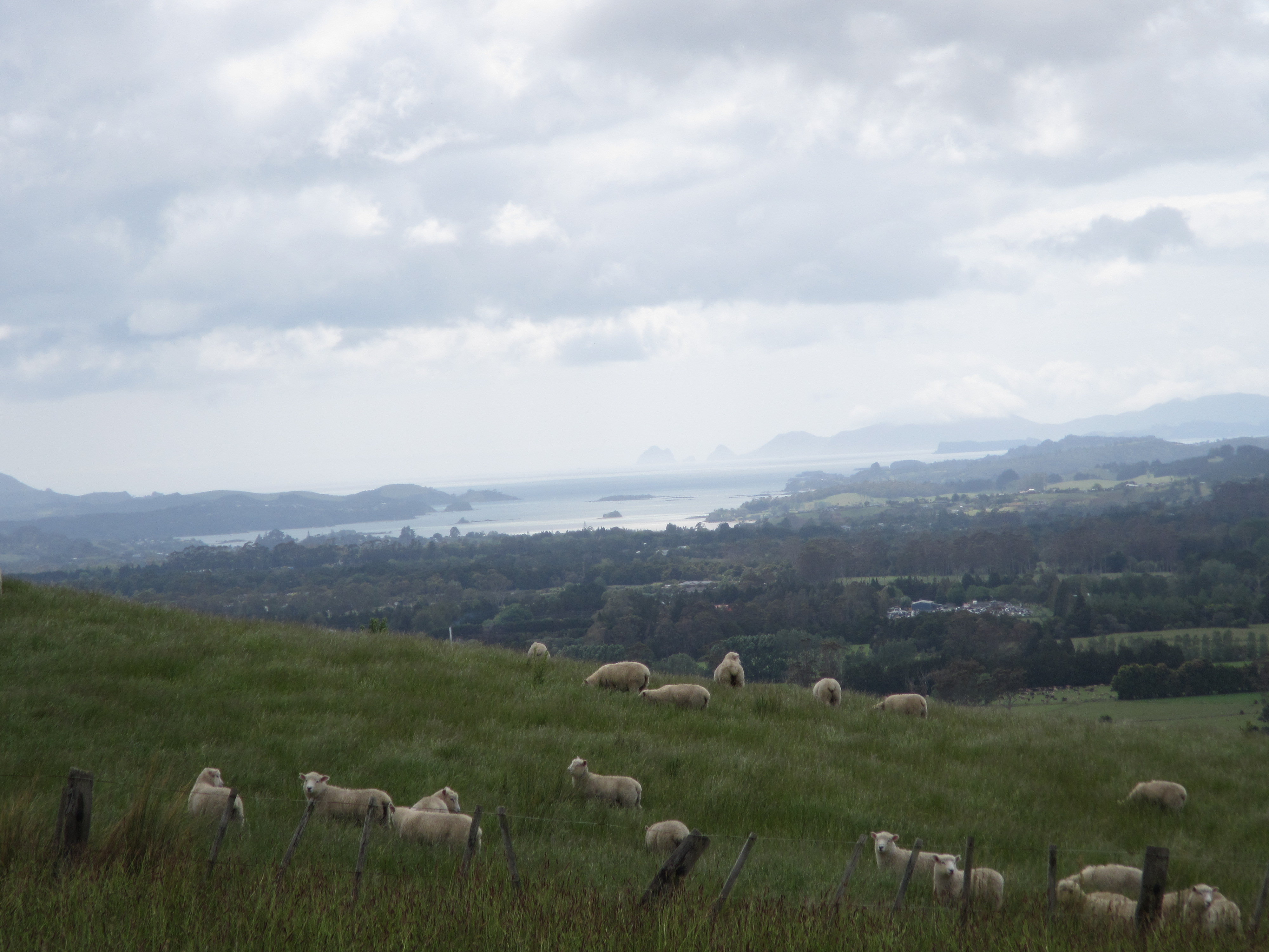
The views from the trig point were amazing. Looking back north I could see the whole path along the estuary I had just crossed, now completely covered with water and no exposed sand bars. Looking down south I could see the 6km beach walk I had in front and could just make out Bream Head although the top was heavily clouded in.

While on top of the hill I checked what reception I had and to my amazement I had full coverage. I knew that there would be next to no reception at Peach Cove and I took the opportunity to Skype home and chat with Jacinta before she takes off tomorrow for Queenstown. It think it was about 6am at home but she was awake. I was planning to meet her in Queenstown but it isn’t going to happen. I’m travelling a bit slower than I would like and I thought I may be in Auckland by now and able to catch a plan. But Auckland is at least another 1.5 to 2 weeks at my current pace.

I hit Ocean Beach soon enough but didn’t really give much thought to the fact if I was racing high tide on the estuary then of course it was going to be hight tide on the beach. This meant slow, tedious walking in soft sand. The surf was too unpredictable to be able to get close to the harder stuff. So on it was. Slow and steady.

Half a mm of rain was forecast for this morning and several mm in the afternoon. As I walked along the beach the morning rain started to chase me from behind. Initially it was just a sprinkle and I didn’t worry about water proofs, knowing that as soon as the sun showed it’s face things would dry quickly. Well as it was, as I approached some rocks with a steep climb up and over, it bucketed down without warning. In minutes I was saturated. I had enough time to grab my rain skirt and give it a test run but it failed in such a heavy down poor. A rain skirt is basically a rectangular piece of silnylon, fashioned into a skirt – the theory being it is much lighter to carry than full rainpants; easier to put on/take off; breaths better and keeps your shorts dry. I think it would work ok for showers but not heavy down pours.

Climbing the steep bank the rainwas so heavy it started to wash the hillside away and a slopy mess of mud and sand started to move in a lava like channeled down the only route it could follow – the track.

At some point on this trail I knew I would have to walk in the rain and today happened to be that day. And I must say Merino garments are amazing and I’m so thankfull for the support that Icebreaker have given me. Even saturated all I had to do today was wring out my t-shirt, put it back on it was still comfortable ton the sink and could wear it straight away even damp. The disclaimer being there was no wind.

So in the downpour it was up and up and up for a 2km ridge climb for a rise of 500m to an old naval radar station on top of Bream Head. I had lunch on top in the cloud. I’m sure there were views to be had but not for me today. Gobbling down some much needed kilojoules I then pushed on for the final 4km for the day to Peach Cove Hut.

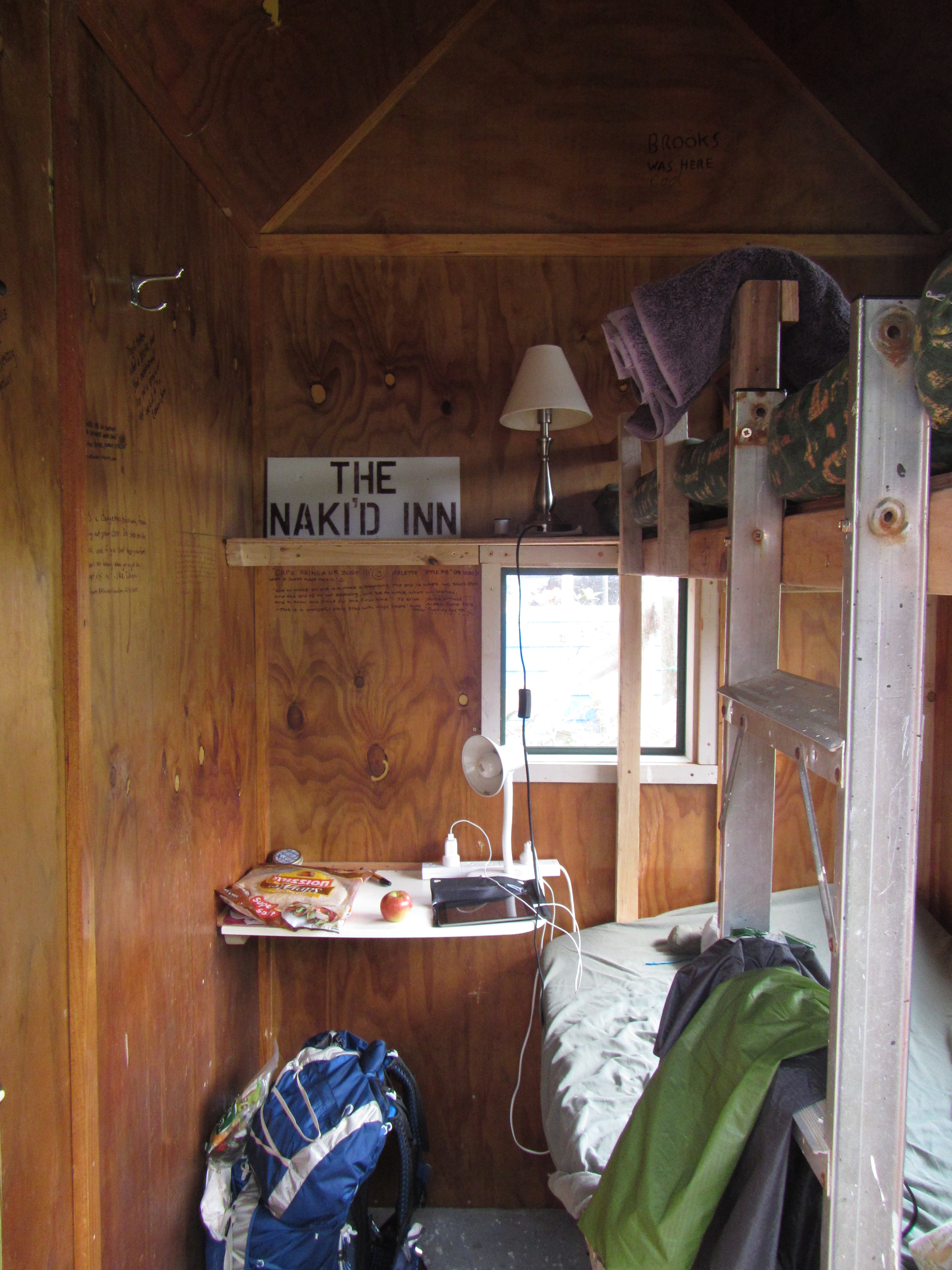
The going was slower than I thought it may be. The track was of tramping standard with a mix of rock, roots and mud however DOC have installed many, many wooden steps. Intermittently and inrandom stops there would be really well benched track only to lead to a knarly section of steep roots and rocks. On top of Bream Head were some amazing boulders and rock formations that the track wound around.  The final climb down to Peach Cove was difficult on the knees with just over 800 steps to contend with! Yes I counted them. But it was great to be at a hut for the night, my first DOC hut. 8 bunks and cozy.

Just as I got settled and hung up stuff to dry the rain bucketed down again. But I would be warm and dry tonight.

At around 4:30am Chris and Cathi arrived, shortly after a kiwi family of four, followed by a pair of kiwi women; and then the rest of the crew: Michala, Sebastian and Stefan. Shana having a rest day the day before also caught up. A busy night at Peach Cove hut. It sleeps eight so all those that booked (including myself) had a solid roof over head while the tramping crew had to opt for tents.

Peach Cove itself is the ideal little cove. If not for the rain I could happily spend the rest of the afternoon under the shade of a tree listening to the breaking surf or going for a relaxing swim.

Long post today, but plenty to say.

image

Day 17: Ngunguru to Pataua.

Distance covered today: 30 km

Total TA distance covered: 366 km

Today is when I rant, bitch and moan about road walking!

WARNING: there is very likely to be frequent swearing in this post.

Seriuously what the fuck was today about other than getting from point A to point B. All of about 4km of ‘trail’ walking today through bloody harvested pines on old logging roads and a short section along a river with two crossings and the rest of the damn way on bitumen roads. Not a single interesting thing to look at today and I don’t think I even pulled the camera out. I did pull the gropro out and have a similar rank which will be aired at a later stage.

What is more, the first 13km of road out of Ngunguru were bloody outright dangerous. No verge to walk on, you’re basically on the white line, tight turns and very bloody busy. And the locals drive like lunatics!

I wasn’t about to start hitching but after 5km of this nighmare an Irish guy pulled over and said “Jump in mate.  Too fuckin dangerous for this shite. It’s a notorious road.” With my philosphoy of saying ‘yes’ to opportunities on this trip, I didn’t have to be asked a second time. In no time Tim had me through the worst of it to the turn off I needed.

I’ve said it before and I’ll say it again, road sections are necessary to link sections of track and to form a continous line from top to bottom of New Zealand – but today was a fucking joke.

Even after the pines another 13km hard slog on similar but quieter roads to Pataua. Given the constant traffic and the need to stay vigilant to make sure you don’t scare the drivers and maintain enough space, it was impossible to even try and kill the time listen to a podcast or audio book – too dangerous for headphones in ypur ears.

Relentless pounding on the bitumen plays havic with the feet. Everyone is having the same hard time.

The consolation at the end of the day was that I found a nice quiet camp site at Treasure Island in Pataua. I was windy and sunny, perfect for getting some chores done like washing all my clothes. Pataua is quiet at the moment but this place must rock in peak holiday season.

Chris and Katy showed up at the same spot as well. I haven’t seen these guys since the Puketi Forest and it was great to cach up, share stories and laughter. They had exactly the same thought on todays road bash marathon. WTF? We talked shop as well, discusing tactics for the next couple of days, how far we might get with the tide conditions, diffetent options and what we may do to get across the Whangerai Harbour to Mardsen Point.

While eating dinner, the man who can not be stopped, Bob, showed up and said that the US girls and Bernard might behind him as he saw them crossing the Pataua footbridge. We have become quiet the trail family. It is great to have people who are experiencing the same journey and shared memories, albeit we are each walking our own walk; at different speeds, stopping at different places, but reconnected each night or every couple of days. I love this life! Think I need to approach the TA Trust about a job – I could walk all the time, with a support vehicle of course, updating the track notes each year and working with landholders to reroute off roads. Rob if you’re reading this – call me.

A really early start is required tomorrow with a 3km section through estuary mangroves that needs to be done at  low tide.  While I wont be walking through at vey low tide around 4am, I’m aiming for a 5:30 get away from camp.


Day 16: Whananaki to Ngunguru

Distance travelled today: 27 km
Total TA distance covered: 336 km
Ok sort of day today. Just going through the motions.
Crossed the Whanakai bridge early this morning, the longest foot bridge in the southern hemisphere, and was meant to start walking around the estuary but the tide was high and it called for a 1km road walk diversion.

Soon enough it was onto the Whanaki Coastal Walk through a mixture of private beach fronted properties and pine forest. The track was really well maintained and resembled a golf course fairway, well mown, well bench out and clearly marked. Specatular views were had over the eastern coastline with calm emerald waters brushing the steep rock ledges. After a couple of hours it was time for a break and I found the perfect spot. Perched high above the cliff line over looking Sheltered Bay, the vantaged point showed the distance that had to be covered to Matopouri.

imageimage

Then it was onto the road walking. Oh the road walking. An unfortuante necessity to link sections of trail but I am sick of it. Most of the road walking is on the Northern Island. It is hard. Hard under feet. Hard with the traffic. Constantly criss crossing the road to make sure you don’t walk around blind corners. Some nice coastal views along the way.

image

Into Matatpouri I headed straight for the shop for some icecream. Trail magic number 1 for the day. I bought a Gatorade and asking for a single serve of chocolate, the shop attendant prompted added 3 scoops “Ice-cream’s on the house. We need to look after you guys.” Nice. A short road walk and then back into the forest.

A few ups and downs. I came across a really nice benched section of track that had switchbacks and steps cut instead of the old straight up and down. I was beginning to think New Zealanders were trying to take the piss out of foreign walkers with these straight up and downs, until coming across this nice track. Then I came on a sign stating you are walking on private land. The landholders have obviously done this great work off their own accord. Climbing over the next stile back into DOC land the track promptly returned to the what I had become accustomed to.

image

Along the way the track passed by a kauri tree so large they had to name and protect it – Tena Moana ‘the big one’. Coming out of the forest towards Ngunguru it was back to road walking. Along the way I saw a trail marker on the side of a power pole, pointing the way to towards ‘trail magic’. The trail led to a microwave oven at the back of a property offering gifts to TAers. I took an apple, sat down and just about inhailed it. Fresh fruit – yum. Juicy apple – incredible.

image

From there it was the last 2km road bash to the Riverbank Homestay B&B where trail angels Melva & Hilton host trampers, allowing them to camp in the veggie patch. I was greeted warming by Melva who showed me around – drinking water, out door hose shower, toilet and veggie patch. The perfect veggie patch that is a rambling mess with food and flowers everywhere. Melva even brought down a bottle of home brewed ginger beer and later preserved fruit and oat slice fir desert.

Initially I had the run of the place myself and relaxed under the shade of a feijoa tree. As I was enjoying desert and conversation with Melva a car pulled up and out jumped the US girls, Michala and Shana, stuffed from a big day but happy as ever after celebrating Thanksgiving today. Their travelling companions from the start Zeeda and Petra finished with the trail this morning and went onto explore other things New Zealand has to offer.

Day 15: Helena Bay to Whananaki 

Distance travelled today: 21 km

Total TA distance covered: 309 km

Tough, tough day. Short distance wise but incredibly humid. There was some rain overnight and the morning was overcast with the cloud cover keeping a lid on the moisture and retaining the suns heat. To top this off much of today’s walking was in thick forest with no wind penetrating through the canopy. It was a sweat fest.

Stephen was off just before me and I didn’t see him again. Vicky past the yard on her way out of town to say hi and I didn’t see her until right at the end of the day. The rest of the gang were still getting packed up and ready to start the day.

By 7:15am I was off onto the road for around 6km following the Owai Stream until entering the Kaiikanui Forest and onto a bush track. It was hot and by 8:30am I was saturated with sweat. It continued to pour out and really sapped my energy. By 10:00am and well into the forest I was onto the rehydrating salts given I ‘d already chugged down two litres of water. There was no way I could keep just drinking water all day.

Along the way, I hit the 300km mark. Nice going me.

image

The forest was nice. One incredibly long ridge line went up and up and up. I had to slow the pace down considerably. Sweat was pouring out and dripping off my hat constantly. But like anything hard and worth doing I reached a pine grove with incredibly views across the coast and Pine Knight Islands. Better yet, up high in thinned maintained pine, there was wind! The perfect lunch spot. I stripped down to my shorts and hung everything out to dry in the breeze. I’ve been in the habit of taking shoes and socks off at lunch to rest the feet and let them breath. It was just what I needed.

Cooled down, fed and hydrated my energy levels were back up for the last push into Whananaki. Following the track down through farmland, a small piece of road walking and some additional paddock bashing, the emerged along side the estuary. And easy stroll then led me straight to the shop for a much needed gatorade. Vicky was here as I arrived but continued onto Matapouri. I was done for the day and made my way to the Whananaki Holiday Park.

image

The guys that run the park are what we trampers refer to as ‘trail angels’, people along the Te Araroa who go out of their way to help TA trampers. On arrival I was greeted with a very warm welcome, ope arms and a huge congratulations for having made it this fair.

The park has the sweetest deal for trampers. For $15 I’m staying in the famous Nakid Inn, basically a converted garden shed with bunk beds specifically set aside for trampers. Included is unlimited wifi, power and recharging, a towel, a warm shower, washing if needed, delicious fresh fruit and a veggie patch to help yourself to. Wow!! Great way to finish the day.

image


imageThey also keep a list of all the walkers who come through the park. To date they have recorded 139, now 140 trampers. The trail has certainly become very popular over the last few years. Only around a third of these guys will make it to Bluff and some that come through are only completing part of the trail.

As I type this, the girls from the US and Czech Republic have arrived and are getting settled.

To top the day off a small rural school, Tangowshine School, is having camp here for a few days and had excess burgers for dinner. You what they say about the way to a trampers heart is through their stomach, we didn’t need to be asked twice. Sven and Katherine have also arrived. Man this trail is busy.

image

Burgers and smiles all round

Onto another pair of trail angels tomorrow Melva and Hilton at the Riverbank Homestay who also look after trampers.

image

Day 14: Paihia to Helena Bay

Distance travelled today: 44km (11km by boat)

Total TA distance covered: 288km

This morning called for a very early rise to meet the water taxi for departure at 6am. The great thing about an early rise was getting down to the water in the early morning light. Calm waters catching the first splashes of sunlight made for a brillant show. There is a lot of money tied up in these parts. MacMansions with commanding views litter the cliff tops to the water edge. Plenty of yatchs to go aloneith the houses.

It ended up only being Vicky and myself for the boat leg. It was a quick ride of about half an hour with Diveops and skipper Debbie. Through the openn waters it was pretty much just a boat ride but as we ended into mangrove areas it decame a bit more exhilerating. The passages were narrow and if you looked ahead you couldn’t see a gap. Luckly the locals know what they ate doing. Just as it looked like we might be about to run aground the boat was careened into a tight banking turn into the next canel. The rising mist off the water just added to the experience.

We were dropped at the landing in Waikare. This is in middle of no where. Vicky and I looked at each other with a knowing glance – what is this place. While Vicky attended to foot repair before the day started I headed off up up the road.

A couple of kilometres in I met a young Mauri boy riding his bike. He had of heaps of questions, one fired after the other in rapid sucession.  Then without a word he just shoot off and was gone.

Further down the road I came across several other TA’ers who had camped by the river. Stefan from Germany was just about ready to hit the trail. He caught up with me just before a section of trail that required a 4km wade up a river. He told me last night was busy with about 8 people staying at the camp site he was at. He wasn’t wrong. As we hit the spot to get into the river there they all were, well most. Michala and Shana from the US along with Zeeda and Petra from the Czech Republic. They were all changing from boots into crocs for the river.

With a 4km stretch wading from shoal to shoal and walking over slippery rocks, I didn’t want to do this in my sandles and so charged straight in with my trailer runners. Much better toe protection, ankle support and grip on the wet surfaces. I knew the others would be a fair bit slower an went on ahead.

The stream will brilliant. Crystal clear water and many small water features along the way, cascading over rocks or logs. But the clear nature of the water messed with ypur depth petception a bit. Many stops wete much deeper than expected with you put a foot down. The eastern sunlight was tricky as well, with the reflection making if difficult to see firm footing. Often it was bling trial and error. Walking poles made the job of staying up right much easier.

Along the river I noticed fresh foot prints in the sand and knew that someone was ahead. As I walked on they got fresher and fresher and the water drips that get kicked onto rocks as one steps out of water were looking fresher each time. So nearing the end of the river section who should I cone across taking a break but Bob. Good old Bob. And talk about timing. I was a bit peckish and he felt obliged to return the favour of a chocolate bar. Bob is treking along this trail just fine and having a great time.

Bob making his way up stream

Bob making his way up stream

The remainder of the day was uneventul road bash along Russel Road to get as many kilometres in as possible. While eating lunch at the Punaruku Marae,Stefan

came past. We had a chat about how far we would push through today. Initially I was thinking of heading towards Oakura Bay but Stefan pointed out a river near Helena Bay that we should aim for. He went on ahead as I finished lunch and we played leap frog on the road for about 10km. As one of us pulled up for a break the other would over take. He caught me again as I collected water from the road side about 2km out of Helena Bay and we walked the rest of the way into the small community.

Helena Bay is lovely. Small but perfect beach. The stream we were aiming for with still a little further on and I just couldn’t do it. My feet were aching after such a long day of road bashing. We looked around but all the ideal camp spots wete signed clearly with no camping. But I was desperate to be done for the day. Seeing a couple of locals renovating a house I approached them to see if they knew where we could camp. Peter, the owner said, “what about here?”, pointing to the back yard. Perfect! We have room for tents, a toilet and water. What more could you want? And so it is I find myself writing today’s blog in my tent in Peter’s backyard as they continue sanding, nailing and general bashing about.

image


imageKiwi’s are such awesome people. From all the people I’ve met us far, locals and trampers, I’m finding that most have inherently good hearts and are willing to help each other out. The property is a stones throw from the beach. Cooling my feet and legs down in the sea was very therapeutic.

Later the rest of todays gang, Michala,  Shana, Zeeda, Petra along with Vicky and Sebastian from Austria all arrived on the scene but chose to camp by the river with the no camping signs. As it turns out they had met Gaye the president of Teal Bay something a rather who gave them express permission to camp where ever they like, and if anyone says anything tell them Gaye said it was ok. I think they have the better scenery but we had the better deal with access to facilities.

Day 13: Kerikeri to Paihia

Distance travelled today: 22km

Total TA distance covered: 244km

Unbelievably good day.  

Awesome stay at the Hone Heke Lodge with hosts Victoria and David. They made me, and all Te Araroa walkers feel right at home. Picking up my resupply box yesterday I realised it was untenable to keep sending a huge box forward so I did some consolidation yesterday and reduced my box to a 6 bottle wine box size and packaged other items to be sent home. David was able to drop me at the post office and I got my boxes sent this morning. 

Then on to the trail it was. Latest start for me yet at 9am. Walking along I came across a middled aged bloke walking his dog. We were both evenly paced and neither could overtake the other so we ended up walking together and chatting for around two kilometres. How nice is that. A complete stranger, showed an interest in what I was doing and it sparked easy conversation that flowed for about half an hour just walking along. 

I soon hit the Waitangi Pine forest. Nice and cool under the canopy and easy walking on edge of gravel where the pine needles had collected. The route through here was really well signed and made for easy navigation. Other walkers had mentioned signed posted water sources along the way but I think these are more like fire dams for the pines and didn’t look too inviting to drink from. Not to worry I had plenty of water for the day ahead.

There are mountain bike tracks everywhere in this pine forest just like most pines in New Zealand. There’s an untapped market to create a trail similar to Te Araroa to link all the best MTB tracks in the country. You would want a support vehicle though. Too difficult to tour and hit the tracks up properly.

Much easier walking today and the kilometres are coming easy. I think my foot issues have stemmed from replacing the original inner soles of my trail runners just before leavng. Silly idea. I ripped out the new ones yesterday and put the originals back in. My feet were very much appreciative. Legs are throughly used to walking 20km plus a day now and no more soreness the following day. 

Walking along in a world of my own and listening to my ipod, the Pixies song came on with the lyric “you will ask yourself, where is my mind?” And i did. For the first time on this trip it was clear. In the moment, not thinking too not much but listening to the music and the rhythm beneath my feet; it was not at work, it was not anywhere really, one of the main reasons for this walk – to clear the mind. 

It’s been great moving on from Kerikeri, my first port of call since arriving in NZ, and with that move forward it feels like flipping the page of a great read that you can not put down and getting onto the next chapter.  The next few weeks should see the kilometres tick over relatively quickly and make it feel likesome headway is being made. 

Approaching Waitangi around 1 o’clock, the sapphire coloured waters of the bay of islands came into view. An easy walked through the golf course and it was onto the Waitangi Treaty ground, the place where a treaty was first signed between Maori Chiefs and the British in 1841. I had to do the touristy thing and have a look through the grounds. Interesting history. I think the treaty, for all it faults that are still being worked through, is one of the great successes of the Maori as a people, enshrining their rights and unifying culture; unlike our indigenous people in Australia who have been so poorly treated and continue to be, ripped apart from their land and culture. 

Arrived in Paihia around 3pm and have the boat sorted out for tomorrow morning. Looks like we may have 3 players in the mix now with Vicky, Jess and myself. An early get away though. 6am departure given the tides. 

Day 12: Zero day in Kerikeri

Distance travelled today: 0km

Total TA distance covered: 222km

Easy, relaxing day today, resupplied and arranging water taxi across Waikare Inlet. The official TA route includes this water section. It’s either a boat ride from Opua or an additional day road walking around the inlet. Think I’ll take the official route.

Teaming up with Vicky for next couple of days to split the ride to Waikare.

So onwards to Paihia tomorrow, early morning start on Tuesday to meet boat at Opua and onto Waikare.

IMG_0875

Day 11: Puketi DOC reserve to Kerikeri

Distance travelled today: 25km

Total TA Distance: 222km

It was windy as hell last night. Gusts over 50km an hour and a little bit of rain. My tent held out fine. Given the sleepless night the previous night I was knackered and slept well right through to sun up at around 6am.

On the road by 7. Matt had already left and the others were just getting the day started.

A nice easy day today through rolling pastures. The Te Araroa is still relativly new and there is a bunch of road walking that needs to be done, connecting the different bits and pieces of other trail. The TA Trust is slowly working at removing long stretches of road walking by working with private land owners to route the trail over their lands.

This mornings walk was on one of the first sections across private farm land, crossing through well stocked, green paddocks and crossing fences using foot stiles to ensure the fences stay in tack and to prevent trampers being bitten by electric fences.

The merino sheep must have lambed recently as all the young ones were with mums who were quite protective and steering them away as I walked through. I thanked them for their contribution to my walk in the form of socks, boxers and t-shirts.

image

Approaching communication towers on Maungaparenua I spied the first glimpse of the east coast. By the end of the day I will have clicked up over 200km on the trail and officially crossed from coast to coast from west to east. While I was resting and taking some photos, Matt arrived. I thought he left before me? He did but inadvertently took a wrong turn somewhere along the way.

image 

Yimage

After the paddocks it was an easy walk along the Maungaparerua Stream and along the Kerikeri river, passing Rainbow falls and nice shaded rainforest areas. I finished the day at Kemp House, one of New Zealands oldest houses (1821) and the Stone Store in Kerikeri.

image

image

Talk about timing. There is a food and wine street party in Kerikeri tonight. Great food, great wine and awesome live music. Watched a group called Strangley Arousing, a young kiwi outfit playing my favourite type of skar, reggae and latin with a horn section. Great drums! 

Day 10: Puketi Forest to DOC Puketi Camp Ground

Distance travelled today: 13km

Total TA distance: 197km

Short day today, only 13km and 5 hours. 

It absolutely bucketed down last night. Luckily, I had made it through the river section yesterday. Had I stayed at the start of the river traveres, as I had contemplated, then I would likely be back tracking today and taking the wey weather bypass as the river would have been too high. I fear this is what Bob, Chris and Katy will have to do. 

It was restless night with little to no sleep had. The huge down pour of big old fat rain smashed heavily onto the tent and was very loud, making sleep difficult. It was unrelenting and did not stop until I literally left camp this morning. I don’t know how many mm but stacks. 

My tent is a single skin tarp tent. Basically just a tarp with a floor and bug netting sown in. There isn’t a lot of overhang between the roof and where the bug netting is sown, maybe 15cm. Anyway the rain was so heavy last night it ended up boucing off the ground, under the tarp and through the bug netting. Only a fine mist once it passed through the mesh, not the whole droplets, but enough to cause most of my gear to become damp over night. Not very pleasant.  

Todays walk was fairly uneventful. It basically entailed completing the river track traverse that I didn’t quite finsh yesterday to the Pukatea Ridge for a solid climb out to a 4wd track. I passed a couple of solo blokes at the freedom camp at the start of the Pukatea Ridge. One of them, Matt, from he US, has also chosen to go as fair as the Puketi Rec Centre, so we’re sharing a camp stop for the night.

The highlight of the day was walking, steep up the ridgeline through a young stand of kauri trees. The ridge was a knife blade with minimal width about it. Early in the morning light with the lingering rain drops falling from the vegetation was amazing. The ridge dropped steeply off both sides and as I climbed higher morning mist hung beneath in the gullies on both sides. 

Arriving at the camp site just after 12 the next few hours were spent drying gear. 

So we could be having a party. Bob, Chris and Cathi all arrived having negotiated the river section. Bob got through yesterday. Chris & Katy took it on today. Very vivid and colourful description from them getting through today. 

Day 9: Makene Road to Puteki Forest

Distance covered today: 30km

Total TA distance: 184km

Today was a long day but not too had until the very end.

I left camp at around 7:30am and hit the road for a good 7km towards Mangamuka. Walking on State Highway 1 wasn’t too bad. There is not a lot of verge to play with and you have to keep crossing the road to ensure there won’t be any blind corners for cars or trucks to clean you up. For the most all the traffic left plenty of space for safe walking. There was the odd car that must have thought it was a sport to see how close they could get to the tramper.

I got to Mangamuka Dairy at around 8:30am and ordered a bacon & egg toasty plus a coffee milk. Lisa was a very friendly and welcoming host. There is not much in Mangamuka and the Te Araroa trail is now bringing travellers from across the globe and their trade who Lisa really appreciated and welcomes in.

While I was waiting for my breakfast to be cooked up, Bob, the older kiwi I met at Utea Camp on 90 mile beach came into the store and shortly after that Chris and Cathi from Germany who I met in Ahipara also arrived. They all camped the night in the back yard of the cafe owner.

Catching up with everyone it occurs to me from their comments I walk very quickly and very far. Am i going too hard at this? I don’t think so. I think I’m setting a fairly good pace. If I only walked a couple of hours each day or only 15km a day it would take me more than 6 months to get to Bluff. It also occurs to me that most people are walking the Reatea Forest and Puketi Forest over 2 days each. All in all, thats a lot of days and a lot of food to carry from Apihara. Bob, Chris and Cathi have all had an extra travel day on me (given I sat the rain out Monday) and I’ve caught them.

Anyway, I eat my breakfast and have a catch up with Bob, while Chris and Cathi hit the road. Today was mostly all road bashing to get to the Mangapukahukaahu Stream – have you got that – Manga puka huka a hu – 24km in total to get to the stream. Then a 2.5km walk down through the stream it self to the junction with the Mangapa River and along some bush track to the Pukatea Ridge.

Road walking was fast but bloody boring to do. There were quite a log trucks and it’s a bit dodgy to listen to the ipod to liven things up.

Just after 12pm I had caught Chris and Cathi at the junction of the Kauri Sanctuary Road and had lunch with them. Their destination for the day was Apple Dam Camp only another 1km on. They took off as I repaired my blistered foot and Bob also arrived. He was also staying at the camp site.

imageI pressed on and reached the stream by 2pm. Walking through it was refreshing. Cool on the feet and cleansing for my trail runners. The creek flowed through a steep gorge, sheer on both sides, lined my palms, ferns and tall trees. The walk consisted of wading from shoal to shoal and occasional across rock bars. Dangerous to do after heavy rain, there is a wet weather bypass option but today was fine. Bright sun over head and no rain in sight.

There were the odd deeper pools to wade through, just under undie height, but nothing to be worried about. I found one really deep hole and jumped in for a cool down but that only lasted a minute or so, too bloody cold.

I finally got to the river junction. Looking at it it is deep! Very deep. The tannin stained water blacks out the bottom but you can tell it is over head height. I can spy the trail marker directly on the opposite bank and initially think it will be a pack swim but that’s just too dangerous. Looking at each bank on my side it is steep and the river level plunges straight down. There isn’t any footing to scrambling around the sides to a better crossing. It was only on closer inspection of the last trail marker on my side of the river and triple checking the trail notes I find a very steep trail leading up hill to the south. I follow this and it soon comes to a much better crossing. All is good and I’m across.

The rest of the day was following the trail along the river until I found a nice camp spot and couldn’t walk any more. Most of the track is sidle and is very difficult on the feet. Timed it just right. Set up, fed and in bed, it started to bucket down rain.