Day 28: Auckland to Hunua Falls

Distance travelled today: 33km

Total TA distance covered: 673km

I skipped the city section this morning and at least a day and a half of road walking through city suburbs, the airport and industrial areas, having walked through these areas before, catching a train from Auckland metro to Manurewa 2km off the trail.

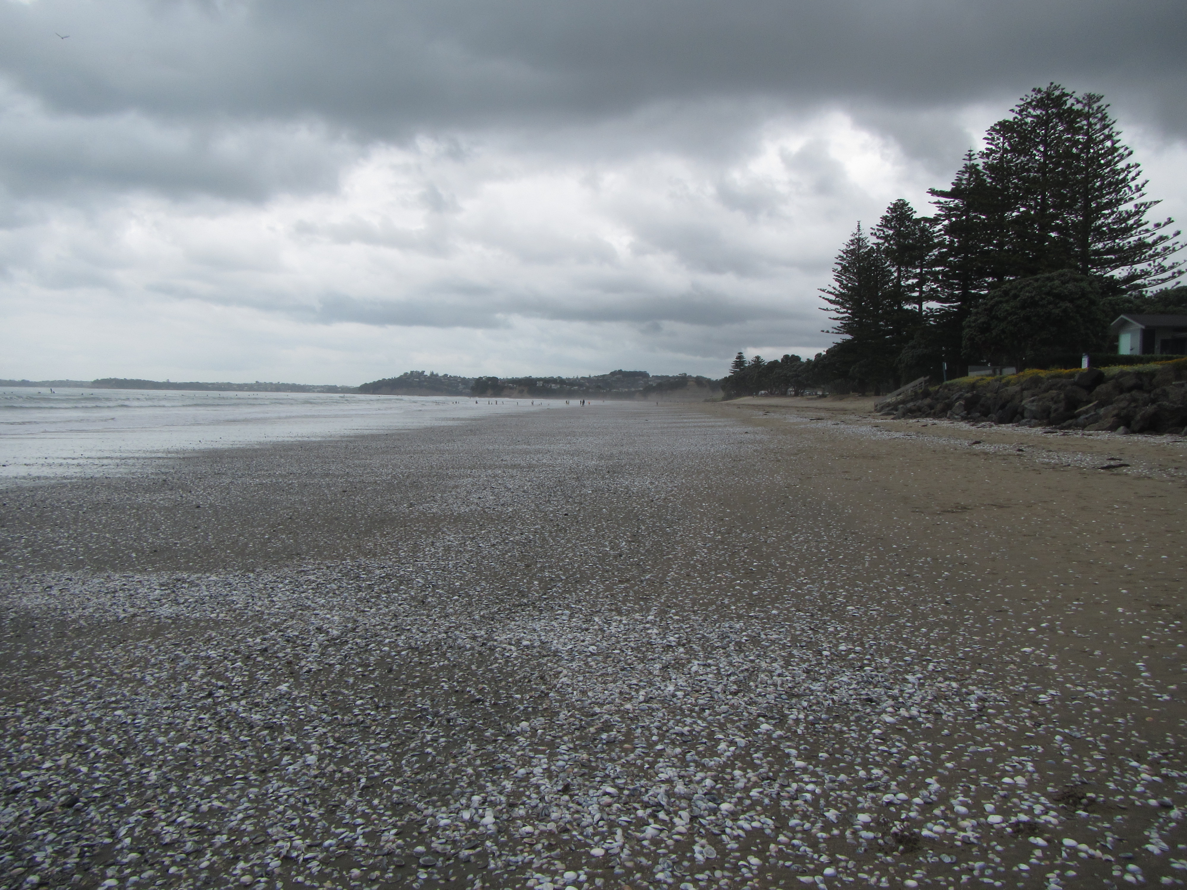
The morning was an uneventful road walk following very busy roads towards the Brookby area. The reason for the roads busyness, the Brookby Quarry. Trucks were continual both ways in lots of 2 or 3, sometimes four. Truck and trailer either empty or full back and forth from the quarry delivering their rock to surrounding areas. This made for tricky walking. And not much verge to walk on and I had to be alert to the traffic. I found myself constantly swapping surfaces under my feet from gutters, stoney verges, bitumen and grassy verges where they were present.

Things got a little quieter on reaching the quarry and turning off onto Kimptons Road to climb up high through pines to a great view looking back north towards Auckland. The Spire stood out of the horizon and you could see the multiple planes lining up in wide formation to land at Auckland airport. It’s great to be past Auckland and moving along the TA. This vantage point provided a fantastic lunch stop. Windy but the views made up for it.

Climbing through the pines it was back onto actual trail for a while. At times the trail was overgrown with head high grass. I would look up and the trail would disappear from view but the obvious foot pad was always there. At times it looked like the trail just stopped but pushing aside some vegetation it was obvious again. So up and over the Clevedon Reserve it was and back down to the small, sleepy Clevedon community.

A cafe /bar was situated right on the trail and of course I had to stop for coffee. A little bit further on it was over the Clevedon Wharf bridge and onto McNicols Road initially bitumen before turning into a metalled road. I loved this road. I was a nice area with country blocks and small acreages. There was some traffic but nothing like this mornings. There was also a quarry further up this road and associated trucks but minimal. Plenty of room for everyone.

Just after this second quarry and on the metalled road I came across Chris and Cathi popping up out of know where from the river. I hadn’t seen these guys since Peach Cove Hut more than a week ago. We walked together for the rest of the afternoon following a great track south along Wairoa River. A nice benched and well formed track to end the day was perfect. Travelling with others and engaging in conversation was also a great way to watch the kilometres fly by.

On reaching the junction between trail and road we had a decision to make. The destination for this evening was Hunua Falls. Take the red pill….. Turn left and continue another kilometre up a bitumen road to link back onto the trail for a short section of up and down to the falls or take the blue pill…. turn right and take the short 1.5km all road walk. With more than 30kms under the belt already today the road walk seemed the quicker option.

We reached the falls and took the obligatory photos. There is a sculpture of an elaborate golden picture frame right in front of the falls which provides the perfect spot to place yourself in the picture with the falls as a backdrop.

The only problem now, as a council reserve there is meant to be no camping. Access is open to vehicles but a gate closes at 7pm. Here’s hoping that an officious council ranger doesn’t fully check the place before closing the gates. Until then its sit tight until after 7pm, wait for members of the public to leave and find an opportunity to pitch tents for the night.

It really is a shame there is no camping here. I can understand the council wanting to minimise the impact by not allowing camping but surely they had in mind car campers and Wicked van backpackers, as it is easy access, who, if camping were allowed may be present a lot of the time and cause damage or leave litter. It’s a lovely area. But what is the Te Araroa tramper to do? Camping infrastructure is absolutely minimal for us on long sections of trail through built up areas. This being just one section. Having walked 32km today already I’m not about to walk another half day to an official camping site. And there is nothing in between.

I reckon all the TA trampers are low impact. We are accustomed to leaving nothing and taking only photos. Pitching a tent for a night will have minimal impact. There are toilets here, so it’s not like will be crapping in the woods and we will guarantee to take all rubbish with us – this is what we do, as well as pick up other litter along the trail and remove it.

Day 27: Auckland Zero Day

Distance travelled today: 0km (not enitrely true walking all around the city)

Total TA distance covered: 594km

Rest day today. Well sort of. There are still many things to be done like resupply with food, visit the post office to send my bounce box and find a gas canister. Other than that eat healthy food and chill out. Might go catch a movie later.

Caught up with Logan at the hostel and had a brief chat. He’s resting up today and tomorrow.

Like the view from my room?

image

Day 26: Takapuna to Auckland

Distance travelled today: 9 km(plus 4km ferry)

Total TA distance covered: 595 km

Easy day today. More like half a rest day really. Found a nice, fancy, waterside cafe this morning close to the campsite, for some Sunday morning eggs benedict. It was a bit weired being back in civilsation though. Surrounded by city folk in their desinger clothes, reading the Sunday paper over lattes, while I rock up in my dirty clothes and unkempt appearance. But they were happy to take my money and my belly was happy with museli and powdered milk for a change.

The walk from Takapuna to Devonport felt really quick for what seemed like a dawdling pace.  I knew I could not check into my roo until 2pm so strolled along nice and easy, a meander really, down the Takapuna beach, where every dog in town was out taking their owner for a walk; through some side streets and back onto more tucked away beaches. Before I knew it I was at North Heads and traipsed around the old military gun emplacements overlooking to entrance to the Auckland harbour. Up high the views across to the city made for a great vantage point for some photos and video. The wind was up though and I’m not sure how the audio will turn out.

image

Down to Devonport and onto a ferry I arrived in Auckland around 11:00am. I rambled up Queen Street on my way to the hostel and had another coffee on the away. Paid up and bags left at the hostel for a few hours I had to do really was saunter around the city.

It’s great to be in Auckland. It has been a mini goal within the bigger mission and marks a milestone. I get to pick up my first real resupply box that I mailed ahead, pick up my maps for the next section and start thinking what’s around the corner. I fly into Auckland when first arriving and it really feel like this trip is underway once I move past it.

Not much to say about the city really. It’s a city. A small city. If you have seen one you have seen them all. You could have been anywhere with the same familiar shops lining the streets. From the ferry terminal it was all Gucci, Louis Vuitton and Prada, before moving into the poor mans designer wear like Rip Curl, Rudd & Gunn, Oakley; eateries galore and gift shops, cheaper clothes retailers; outdoor shops (now we’re talking) and more easteries and speciality stores. I had a browse through but I really don’t need anything and don’t want to be carrying any extra weight. I must confess I did check out the outdoor stores but didn’t spend a cents. I will, however, be buying a gas canister tomorrow; in addition to a food resupply; and posting my bounce box ahead – probably to Taumarunui as I don’t think it will take too long to reach Hamilton.

Looking ahead, I think I’m likely to skip a day and catch a train through Auckland rather than spend a solid day walking 40 kilometres through city streets and suburbs. Where is the fun in that? It’s just a city and I don’t feel the need to complete this section just for the sake of staying on an concocted continual line. There are the trampers that must walk every simgle kilometres along the line, to the letter – to those people I say good on you, that is dedication. There are those that just want to do the fun bits and will hitch around most walk walking sections or entire sections all together – to those guys I say great, have fun, you’re only likely to do this once. And there are trampers like myself that will stick as close as possible to the main route but are willing to make some small changes along the way.  As they say, hike your own hike. We’re all doing this trail for our own reasons in our own way and don’t need to justify our decisions to anyone but ourselves; and shouldn’t judge the decisions of others because they differ from how we think Te Araroa should be approached.

image

Day 25: Stillwater to Takapuna

Distance travelled today: 24 km
Total TA distance covered: 586 km

Cruisey day today.

Pretty typical morning. On the trail by 7am and headed towards the Okura Estuary. I had the Okura river to cross this morning which could only be done on low tide or an hour either side. The approach along the coast was 4km and fairly easy. Only a couple of headlands to get over.

In a thick section of the track I came across a group of trail runners out for their Saturday morning training run. All looking very fit and geared up in their active wear and smelling of deodorants and perfume. If I came smell such things from a distance it only means one thing, my nose has become attuned with my own natural odour and I’m sure its not pretty. The trail was narrow and they had to pass close – sorry guys, deodorant free for 25days!! Pleasant.

image

Soon enough I was on the beach and past the historic Darce Cottage, then onto the Okura River. The tide was mostly out and I could walk virtually right across all of it to the last big channel. It wasn’t quite low tide yet. I had an hour to go but it should be crossable. It is meant to be hip deep. The bottom could not be seen in the murky water.

I moved across to the edge of the river to where I sighted navigational poles. If they do cross, trampers are meant cross between the 4th and 5th poles in from the river mouth. Counting them I thought I was in the right spot.

I stripped down to my boxers and made sure all my valuables and dry clothes were secured in dry bags and entered the water for a test run without my pack. A couple of feet in, so far so good. Up to my knees, thats ok. Thighs, getting deeper. Hips, belly button, maybe I should wait the extra hour. Stomach, arm pits and only half way across. I couldn’t do it just yet and was thinking I’d have to wait out the extra hour.

Then getting out of the water I spied a couple of extra marker poles that were not there before when I first looked. Silly me. I was too far down the river and hadn’t paid enough attention to the poles. I needed to walk another 200m out along the sand spit towards the ocean to reach the 4th and 5th poles.

Righto then. Test run two. Ankles, knees, thighs, so far all looking good. Waist, waist, waist. Awesome. It was not getting any deeper and I made it across. Now I had to repeat the crossing twice more, once to get back to my pack and twice to get it across nice and dry. Pack balanced on my head, I made my way back across unscathed.

Dried off and in dry clothes I made my way around Piripiri Point and 3km down through Long Bay Regional Park. This is a rocking park. Very busy given it’s short distance from the city and it looked like half the city was out for a Saturday BBQ, picnic or wedding. I coped some strange looks from the city folk as I walked through in my tramping gear, poles in hand.

image

Then once through the park it was in the actual burbs, passing through streets, between houses and down lane ways. The walk was pretty good and took in much of the cliff top walks with great views out over the water. This continued on for the rest of the day until Takapuna where I had a camp site booked. Very busy park.

imageimage

Some of the walking was hilarious. Walking past suburbs and suburbs of Auckland’s equivalent South Yarra / Toorak equivalents (Melbourne’s posh suburbs for those not in the know). Mercs, BMW’s and Audi’s galore. Extravagant, cliff or waterfront properties all firmly secured between big fuck off gates with buzzers. I must have been quite the sight.

But I must say thanks to many of the properties who have allowed public access along the Te Araroa and the numerous walkways. You are virtually walking through some back yards and looking straight into kitchens, dinning and lounge rooms. And if some property owners choose to be on public display sun baking topless or in g-strings who am I to judge. Just keep telling yourself Mick – look but don’t stare! And definitely don’t wave and say thanks for allowing us to walk through. Or stop to take photos, keep moving through.

Day 24: Puhoi Pub to Stillwater

Distance travelled today: 32km
Total TA distance covered: 560km

Enjoyable day today.

I woke this morning looking for my best friends, my walking poles, but they were not to be seen. Then I remembered arriving at the pub yesterday and after another big day, dumping all my stuff out the front while I sorted out a room. I remember taking my pack up but leaving my poles near the door of the main bar and there they stayed. I must have passed them half a dozen times last night as I was in and out for handles of Tui.

Luckily, someone had found them on closing and put them behind the bar for safe keeping. I was able to collect them when the pub started opening. Phew!! Was not looking forward to forking out for new ones, particularly given I was so attached to these  – they have served me well. They almost have names. I’m sure one is Irish. It keeps talking to me in an Irish accent 🤔. Waiting around for opening meant a bit of a later start but that was fine. I was able to roll with the punches and take today as it comes. Today was sort of open ended as I didn’t really have a destination other than to position myself for a low tide crossing of the Okura river tomorrow morning.

From Puhoi, the current official TA route requires a 7km kayak down the Puhoi River to the Wenderholm Regional Park. To kayak however requires an outgoing tide and it wasn’t expected until around 2 in the afternoon. I had two options. I could have a relaxing day, wait for 2pm, do the kayak and get a bit more trail time in during the late afternoon, possibly to the end of the Orewa beach; or option two, hitch around the river section straight to the park and the trail. I chose option two to get some distance in and one step closer to Auckland.

Leaving the pub and heading across the road to look for a ride I ran into Vicky who camped nearby and was on the hunt for coffee and a relaxing start to the day. Good choice. She was running with the kayak option. We had a quick catch up. Turns out she wasn’t far behind me in the Dome forest and camped out on top of the other high point on the range.

I walked just out of Puhoi to the main state highway and had a ride within 5 minutes of sticking my thumb out. An older guy in a BMW comlete with plush leather interior pulled over (actually he drove past, did a u-turn over double lines, and u-turned again to roll up besides me), started rearranging stuff from the front seat to the back. I asked him if he really wanted me in there, being tramper trash and all. I didn’t want to soil anything. He had no worries. Said he was a tramper and climber himself and only too pleased to help.

So a short ride later and I was at Wenderholm. The tide was low and it was easy walk following park tracks and beach to Orewa. It was love at first sight with Orewa. It had a really good vibe and was the perfect sized town to live in. It had everything you need plus more and well situated outside the hustle and bustle of Auckland.

It was a rocking spot for stand up paddles boards in the soft surf. I’ve never seen so many in one spot. The tide way out, exposed the sand and a covering of shells. They crunched under foot with each step down the beach.

image


imageOff the beach and under the bridge the next 3km was on a walkway around the estuary. Very popular with joggers and walkers out for daily exercise. I eyed up many of the nice houses and manicured gardens right on the edge of the walkway. There is some money invested in these. Great views for sure and easy walking access to town for the residents but way out of my price range. Still nice to see how the other half live.

Once around the estuary it was back onto the roads and essentially walking through suburbs and industrial areas until out to the rolling hills south of Orewa. The walking was hard again. Tight turns and minimal verge down towards the Stillwater Boat Club.

It was in a park just across the road from a caravan park on the water edges, I just got off a skype chat with Jacinta and was just about to start the next section of trail. I knew I was not going to cross the Okura River until the morning and was going to walk the next 4km to a section of trail to a bush block and stealth camp; it would only take an hour, when more generous Kiwi support reached out to me. The holiday park owner was driving out, came over to me and said “You crossing the river tomorrow?” Me: “Yeah mate.” Owner: “Low tides about 9:30am. Stay here. I don’t charge Te Araroa Walkers. I’m heading into town for an hour but chill out in the common room. There’s mattresses in there, thrown one down on the floor tonight. I’ll given you a token for the shower when I get back.” Me:”What! That is too much. I have to at least give you koha.” Owner:”Nah. Everyone else gets charged but no charge for you guys. We need to look after you. Besides you never need much, just a place to sleep, cook and a shower is always nice.” Awesome!

And so I find myself enjoying yet more kiwi hospitality. A free nights camping in a gorgeous area right on the water. With low tide at 9:30am it is the perfect spot to relax for the afternoon. If I leave at 7am and get the four kilometres in, it will set me up perfectly to cross the Okura right on low tide.

Perfect free camp space.

Perfect free camp space.

Day 23: The Dome to Puhoi Pub

Distance travelled today: 29 km

Total TA distance covered: 530 km

A great start to the day!

Camping on the Done wasn’t too bad. I had just enough flat ground for my body to have a decent nights sleep. I knew it was only 2km to the highway from here, mostly down and on a formed track from a viewing platform 1km in. Better yet, the track from the Dome ends at the highway and the Dome Cafe.

I made it to the Cafe just after 7am and got stuck into a big breaky of bacon, eggs, hash brown, mushys, toast and coffee. The cafe owners really nice and happy to have a chat. They certainly looked after me. Breakfast taken care, the cafe filled my water bottles and made me a delicious lunch to take with me – two rounds of meat and fresh salad sandwitches. I would eat well today!

Just before leaving the Cafe a tramper who would take on the southern island later in the year arrived for a training hike, complete with flour bag loaded backpack. Yes..training is a good idea. Wish I had done some more. Actually I wish I had done at least some.

Crossing the highway it was straight onto gravelled country roads for the best part of the day. An uneventful morning really. But I did find the area between Smyth Road and Mathews Road about 6km out of Warkworth to be really enjoyable. The country blocks were perfect. They were in the Goldilocks zone – not too big, not too small, not steep but undulating and lush. I could picture myself living on such a property. Close to a regional town but not right in it and great climate for growing enough fruit and veg and running some animals to keep us healthy. Just need a job to go with it or a complete change of lifestyle.

My Into the Wild magic bus moment.

My Into the Wild magic bus moment.

What's the difference between a flower and a weed? Only your judgement.

What’s the difference between a flower and a weed? Only your judgement.


From there as the trail climbed steeply through harvested pines towards Moirs Hill the trail got tedious. It was flat out boring! How many sections do we have to walk through harvested pines. No views to be had and in the baking sun. Not enjoyable. The mental game started to kick in. I was thinking this is crazy. I’ve already past 500 km, how much more of these crap sections of trail do I subject myself to. It was not fun. It was hard work! If its no fun and hard work why am I doing this? A low moment for sure but forgetting the big picture. In half thought about quitting but only half. My other brain said “this is easy. Its just walking. Want to sit in an office in front of a computer? The suns out, its not raining. You’re belly is full. This is great.”

At the start of this trip I invented a rule for myself. I can quit but just never on that day I think about quitting. If I still feel like quitting the following day then it will be decision time but just never at the moment I feel like quitting. And so I pushed on.

The situation changed at the top of Moirs Hill as I hooked into my yummy sandwiches, got some energy back and looked ahead at the thought of a beer at the Puhoi Pub at the end of the day.

So after lunch, completely piped up and back on my A game, I made the final push towards Puhoi. I knew after Moirs Hill it was back onto some more decent trail and mostly down hill. I virtually skipped my way to the Pub for the next couple hours. Oh the highs and lows of trail life. It changes so quickly.

I made the pub by 3pm. Having booked a room a couple of days ago which was great as they are limited and it is impossible to rock up and expect to find a bed.

The rest of the afternoon is as one should expect, multiple beers and a pub steak dinner. I told you I would eat well today. Being happy hour is all the more special.

image

From here I reckon Auckland is 2 days away and I reserved a room at the YHA.

Day 22: Pakiri to The Dome 

Distance travelled today: 24 km
Total TA distance covered: 501 km!! Wohoo.

Today started off alright. A little road walking from the Pakiri camp site to begin the first climb of the day. And a biggy of a climb it was. A little under 2km to climb from sea level to around 350m through paddocks. As I started the climb I came across a Macpac gortex jacket that had obviously been lost. Vicky was in front of me but I noticed she had a dark jacket normally secured to the side of her pack and didn’t think it was her’s. There were no other trampers that I knew of in front as everyone else was in came when I left so I’m assuming it was dropped a day or more ago. I’m sure the owner is going to be pissed when they find they no longer have their jacket. The climb was steep to say the least and got the heart pumping. As is often the case I started the day with dry feet, but walking through the long grass collecting the overnight condensation they were soon soaked. That was nothing compared to what was coming.

At the top of the climb and entering into the Ohama the views across the Pakiri coast were amazing and clear. At the distance I was though the point and shoot camera just could do it justice. Views streched out across the coastline I’d been walking yesterday and right around the surrounding hills and farmland. The track entered pines of the Ohama Forest before quickly switching back to paddock for a short while after climbing a stile and moved into an area of long ago harvested pines. I caught Vicky at this point and kept moving through the regenerating area.

Now when I say regenerating area, what I mean is the area has vegetation on it but not pines. The next section was a full corridor of gorse bush mixed with blackberries and mud. The trail descended on some gnarly red clay and was difficult to keep footing. A times it was easier to go into a controlled glissade using my poles to stay up right. While it wasn’t a fight through the gorse it wasn’t much fun either. I was in shorts and t-shirt and constantly had to push spiky branches out of the way with my poles. To make matters worse my clothes were collecting all the moisture off the plants and I was still fighting mud. It was a tough section but at least their would be less moisture off the veg for the trampers following  behind me.

After this the trail turned onto DOC land, part of a scenic reserve. The going improved quite a bit and was really enjoyable for a few hours. It was challenging with a few rock scrambles and some rooty sections but I found myself in an amazing state of flow and chewed the kilometres down. I was moving really fast but able to take everything in at the same time; the smell of the flowers; finding foot placements between the roots; the vivid colours of the leaves and understory in the morning light.

Before I knew it I was at a high point of this ridge and came across a constructed wooden deck. A good stop to rest. Initially I had no idea was this was but reading the track notes I learned it was a helicopter platform – makes sense, there was a comms tower close by and no roads. I had seen this tower on the initial climb up through paddocks but didn’t realise it was in the middle of no where. Just thick jungle surrounding it. Another 10 minutes on and I came to the comms tower.

The trail then started to descend through the forest towards the Makakana Valley and I can only describe this as the descent from hell. It was horrible. Very steep. Very muddy and slippery. I nearly when arse over tit on multiple occasions. Walking poles became my best friend. I’m not sure how walkers are getting through sections like this without them. But worse was to come.

The trail climbed a stile and entered into private property. There was absolutely no constructed track along this section at all. It was like the property owners had granted access to their land but neither the TA trust or the owners had done anything other than to define a route through. The route to follow was basically where others had previously past, slipping,msliding and hanging onto vegetation for dear life. Again, incredibly steep and slippery. Long run out sections of 10-20 metres where you slide. This makes for a messy route and highly erodible. Then in the middle of nowhere you find a bridge constructed across a gully only to enter back up hill on similar steep, muddy shite on the other side. The bridge is useless. Enough damage has been caused on either side, and I really don’t see what the bridge is protecting by being there. From here the track sidled around a hill and was of the same standard. Nothing benched out. The sidle was out sloped on muddy ground and was tough going to the road. While the trail has been fairly quiet in terms of numbers up until this year, the route can probably get away with sections like this but I feel that as the trail becomes more popular significant damage may be caused and perhaps some infracture wouldn’t go astray, even a minimal hand cut bench or steps would help. But I can understand the property owners not wanting to take action being out of sight and out of mind, plus they have so much normal property maintenance to do; and I can understand that the trust has limited funds and oversees 3,000km – it can not be everywhere at once to form up nice sustainable trail. Perhaps I’ll start raising money to put towards this cause.

What a relief to have some road. Never thought I would say it. A road bash for around 3 kilometres and it was back into the forest – The Dome Forest. I was making excellent time and had my sights set on marking it to Warkworth for the night. I got to the start of the Dome Forest just after 12pm and stopped for a lunch break.

Do you need some wellys?

Do you need some wellys?

The start of the forest was on old forestry roads but soon entered into a scenic reserve. This was pleasant enough but soon became tough going. More mud as it descended down towards the Waiwhiu Stream. And the mud kept coming!

While it was bad and slow going I’m thankful that I completed all of the northern forests and experienced mud there. Now everything is relative and comparable and I can say to myself yep this is muddy but lucky you are not walking through the Reatea forest and lucky it is not raining. For all the trampers who avoided the northern forests, I can only imagine what they will be thinking heading down into the Waiwhiu valley.

At the bottom the trail crossed the Waiwhiu Stream itself. A beautiful tranquil stram. So quiet. I plunged straight in and wash my shoes, socks and legs that were caked in thick orange mud. But I needn’t have bothered as the Dome Forest had more in store.

image

The day was getting away from me and it was around 3pm when I crossed a larger river, hitting a forestry road. I found a nice camp site with access to water (my water was getting low) but I was determined to keep going to get to Warkworth. That didn’t happen.

The Dome Forest proved to be a bit much and I under estimated how long it would take to get through to the SH1. The trail was very rooty and difficult to find foot placements. For long sections you are basically walking on roots and not even hitting the ground. This proves difficult for the feet, particularly in trail runners with thin soles and not much support. Progress was slower than I would have liked but I pressed on.

There were not many camp sites within the forest given the jungled natured of it and the vast amount of protruding roots. It wasn’t looking good to make it out to the highway but I thought a mountain with a name, The Dome, must have a cleared stop for a camp and so I aimed for this. To reach it though required another major climb up steep, muddy ground. I pushed on but became extremely frustrated when the trail would dive off down hill. This is a climb yes? Why is the trail going down hill instead of following the high ground? This happened on several occasions.

Time was getting away and my water situation was not good. I knew I wasn’t getting out of the forest today and on second thinking realised I didn’t really need to get to Warkworth anyway. I had enough food for the night and probably just enough water at 600ml if I had a dry dinner.

So new goal in sight – The Dome. Depending on which map series you refer to, the Te Araroa 500km mark is either just before or just after The Dome. That would do me for the night. Continuing to climb and topping out at the trig point I was done for the day. It was disappointing to find that the Dome doesn’t have a cleared top and no where really suitable for a tent. I made do setting the tent up right there in the middle of the trail. At 5:30pm I didn’t expect anyone to be following up behind – the sensible trampers have already found digs for the night and are cooking tea.

image


Day 21: Manawhai Heads to Pakiri

Distance travelled today: 28 km

Total TA distance covered: 477 km

Surprises all day and welcome to summer!

With 28km to cover today mostly on road and beach, I was expecting today to be another long day. Distance wise it was long but time wise, I surprised myself, and was in Pakiri my end point for the day at 3pm! Nice. And my feet and legs feel ok.

Also to my surprise I’m starting to become a morning person, unheard of at home where I relish any opportunity to sleep in. On the trail, typically I’m away by 7am. My theory being to get as many kilometres in during to cool mornings and avoid the baking afternoon sun if possible.

Today was no diffetent and I left the Coastal Cow just before 7am. To start the day I had a 5km road bash between  Mangawhai Heads and Mangawhai on the busy main road as the locals headed to work, dropped kids off to school and travelled to do what ever else people do during the morning rush. I was at Mangawhai by 8 and made for a cafe to get my daily fix of natures good bean. The perfect kickstarter for the day. Another 7km road bash to the beach followed.

Arriving at the carpark just before 10am I met a french couple Owen and Selena who were getting ready to commence their walk for the day. They had the fortune last of meeting a couple of locals last night, finding a place to stay and getting a ride to the beach to avoid the road walk.

We had a quick chat about the tides today and the possibility of having to wait for the high tide to lower later in the day for a river crossing half way down the beach that is meant to be thigh deep on low tide. There were three river crossings to contend with today, the first only a 1km down the beach.

This first crossing was easily negotiated. The tide was still coming in and there were plenty of sandbars to get between the channels of water flowing out to sea.

By 10:30am I was at Te Arai Point, 3km down the beach, and much to my surprise had covered 16km and more than half todays distance already. Great. I knew that after climbing up and over Te Arai point there was a 12km beach section remaining for the day to Pakiri. This meant I had all day to meander and ramble along the beach in no particular hurry. Te Arai Point looks to be a popular surfing spot and I had a good 15 minute break here, refuelling and rehydrating as I watched the local surfers perform their magic in the rough surf.

On the other side of the point I continued on, taking frequent breaks to strech my legs and feet. Half way along I came upon the big river crossing for the day. It was around 12:45 and the tide was high but on approachng the mouth I found it to be no higher than shin deep and easily crossible. Maybe this is an indication of how dry this summer is expected to be. On the other side I headed for the dunes for lunch and a chance to dry my feet.

The rest of the day was a long, slow beach walk for 12km. My feet were holding out well but along the way I was thinking I really must purchase a tennis ball in my next resupply to roll under my feet at the end of the day. Seriously about 50 steps on, the universe provided. I am now the proud owner of a well used, sand encrusted tennis ball courtesy of the sea.

Another surprise for the day on arriving at the holiday park in Pakiri. I was setting up and met Ian from British Columbia, Canada. Ian was wearing a t-shirt with Chetwynd Initial Attack printed on the front and I immediately said, “Hey, I was at a fire in Chetwynd last year.” He said “Fire 221? You were part of the Aussie contingent?” Me: “That right we were there for 5 weeks.” Ian: “Wow it’s a small world. I was the storeman there for a couple of weeks. You guys did great and we would have you back anytime. That fire ended up with 6 foot of snow shortly after you guys left and was dead. Great job.”

So I’m sure tonight will be spent talking shop and talking trail with Ian. Owen &  Selena and Vicky also arrived at camp and I’m expecting Sven and Catherine who were also aiming for Pakiri tonight. I think after putting in a couple of big kilometre days I’m probably a day in front of the group I was walking with. I haven’t seen anyone from that crew for two days. No sign of Logan today either but I think he was after a short 15km day today.

Progress is good and I think Auckland is only another 4 or 5 days away. Think I’ll have a two day break there.

The biggest and best surprise arrived at the end of the day. Well I’ve said how great kiwi’s are right? Just in case, I will repeat it. Kiwi’s are absolutely amazing!! Kevin, a follower of this blog, from Leigh just down the road from Pakiri, knew I was going to be in town and arrived at my tent with beers in hand! We had a great chat over a couple. Thanks mate. Very much appreciated. All the best for your own Te Araroa adventure in the future. Get out there and do it.


Day 20: Waipu to Mangawhai Heads

Distance travelled today: 29 km

Total TA distance travelled: 449 km

Big day today. Punched out 30km and made peace with the road.

It dawned on me today there is not much I can do about the road walking and not much I can do about the weather.  I can hitch the road sections but I don’t want to do that as I aim to complete as much of the trail as possible; and I definately have no influence on the weather. The roads will always be there on this trail and the weather is constantly changing. The only thing that is within my span of control is my attitude. So I changed it.

Straight out the door it onto a 9km road walking section and it was raining. I took a deep breath and embraced the situation with open arms. I thanked the road for allowing me to increase my speed a little and thanked the rain that it was cool and that I didn’t need to slather myself with sunscreen just yet.

Most of the day was fairly uneventfull with a bitumen road turning into metalled road as I headed off the main drag and into the pines. Plenty of recent harvesting in these parts and an active logging crew working up Cullen Road. Shortly after it was onto the Brynderwyn Walkway.

I swear the TA maps are ripping us off a few kilometres each day and we awalking more than shown. Like good loggers do, they mark the road sides with kilometre markers to make communication between trucks easier and Cullen Road was no different. From the start of the metal the markers were inplace and the TA maps showed 4 kilometres to the turn off to the Brynderwyn Way. But I reached the 4km sign and my GPS showed another k to go. 1 additional kilometre that will be walked but not recorded on the official mileage. This seems to happen daily. It’s really not that hard to get the markers right in GIS. Rob – if you are reading, I’m fairly handy with GIS, if only you would find me a job with the trust.

image

Getting to the end of the walkway was good as I knew there were issues last year with one resident not happy with the trail, errecting razor wire and attempting to cover the trail markers. Looks like the route has been resolved as DOC have a nice gravel track that is clearly marked past this particular house. The razor wire is still on the fence but well out of trampers way. Then it down, down, down on a very steep gravel road through what is planned to be a new subdivision. This really worked the knees and feet.

The first half of the day always seems to fly by and I cover quite a bit of ground. By 13:00 I’d knocked out 2/3 of the day but the last of the day always seems to take so long and I feel like I’m going backwards. This is when the body starts to complaint and you can feel the weight of your pack. This is when I just have to slog it out and get the day done.

The trail switched into private land. Moving through paddocks was tough work. The ground is rutted from stock and the surface really uneven making walking down slope really unsteady. Good to take it slow. A few major ups and downs along the way. That’s my other moan for the day, the trail notes. They are so understated in the descriptions of the trail sections. It is much harder than what they make out and makes it difficult to gauge how long a section will actually take.

Today held the best for last. Throughout the day there was low misty cloud cover eveywhere and minimal views but getting out of the paddocks and onto the Mangawhai Cliff Walkway that all changed. I guess the sea breeze was enough to push the cloud away and opened by a vista of steep cliffs crashing waves. The walkway it self was the final 5km of the day. It was well benched out, a nice walking grade and gravelled. An another hour and I was in Mangawhai Heads.

image

I found the Coastal Cow Backpackers and Logan, another TA walker who I hadn’t met yet. While I was at the Four Square resupplying. Sven and Catherine also arrived and Sven offered me a much needed beer.

I found a title for my movie at the end of this journey. You read it here first so I’m lodging copyright “Life at 3k’s – end to end across New Zealand on the Te Araroa”.

Day 19: Peach Cove Hut to Waipu

Distance travelled today: 33 km

Total TA distance covered: 420 km

Perhaps I would have been better off in a tent for a good nght sleep. The idea of a hut yesterday seemed like a good idea. In hindsight I didn’t factor in the constant tossing and turning; snoring, frequent ups and downs of my hut mates off to the toilet, and the occasional although I’m sure unintensional door slam.

I think I just need more sleep but it didn’t come easily last night and there was no time for a sleep in this morning – I had a boat to catch.

Packing mostly last night made for a quick exit out of the hut at 6am. Throwning my sleeping bag into my pack, topping up with water and putting my stnky trail runners on, I made for the climb up the 803 steps (thanks Whytey – not sure who’s authority but I’ll accept it, I’m often day dreaming on the trail.)

I had a boat ride booked for 11am with David Chapey, a local at McLeod Bay, some 12km away, and needed to climb a mountain, traverse a ridge and climb down the other side to get there on time.

I took my time climbing the stairs out of Peach Cove. I knew it was going to be tough rising from sea level to 370 metres over a distance of 400m. The weather was mucking me about at bit too. It would start to rain and I’d get my jacket and skirt out (I’ll get you a photo YT) but it was just too hot. I think my jacket was getting wetter from the inside with sweat. The rain would stop and it was too hot to continue wearing this stuff so I’d take it off. This cat and mouse game with the rain and jacket continued for a long while.

Climbing steeply up onto Mount Lion with stunnng views on three sides. I could clearly see the route I’d taken yesterday and the massive boulders that stand like sentials over Bream Head – these were in cloud yesterday. I could also see the Marsden Point warf and oil refinery, the long beach walk ahead of me later today and the numerous sheltered bays I was headed to, to reach the boat. The view was spectacular and I decided to eat my breakfast overlooking the vistas below.

image

From there it was a steep climb down another serious set of steps to Urquharts Bay. A quick road bash around Urquharts and McKenzie Bay brought me to Taurikura Bay and a small shop. It was time for second breakfast – this is Middle Earth – of coffee and meat pie. Yum. After a week of trail food my stomach thanked me.

I knew Chris and Cathi were aiming for the same boat and were somewhere behind me so I phoned to see that they were on track. On confirming all was well and we would all get to McLeod Bay just after 11am, I phoned ahead to David. Chris and Cathi were about 2km behind and just after I confirmed with David, I got a text from Chris saying they had scored a ride with an offering local at McKenzie. Half their luck!

I continued on to meet David at his house and the quick ride across the harbour. The waters here are crystal clear with great visibility down quite a way. In about 15minutes we were across.

It was then a short road bash around the oil refinery and back onto the trail along the beach. Again I hit the beach walk at high tide and it made for tough walking. Along the way I hit the 400km mark.

After around 7km I reached the Ruakaka River mouth that on low tide is waist deep. High tide, there was no chance in wading across. But as it happens another local Simon was on the other side of the river in a double kayak and waved over to me. In no time he cut across the water to reach the side I was on and offered to take me across. Awesome! Trail angels abound.

Then for a 5km section of sand, passing Uretiti Beach camp and onto Waipu. Another big day. The upside, my legs are solid as bro.

I found the Waipu Wandereres hostel, a really small, 7 bed hostel with a homely feel. The owners weren’t home so I called and they said just make yourself at home, which I did easily. Washing done, clothes dry, showered and resupplied.

Later on Vicky showed up, who I hadent seen for a couple of days, and a German couple I met at Whananaki, and who feature in an earlier photo of us tucking into burgers, but I can not for the life of me remember their names – would it be rude to ask at this late stage? No sign of the rest of the crew. I think they opted for a shorter day to Ruakaka.

I can highly recommened the Waipu Pizza Barn for dinner. Gourmet pizza and craft beer. What more can obe want. The perfect meal in my mind. I tucked into a Globetrotter Pizza – venison sausage, caramelised onion, streaky bacon, garlic, tomoato and copious amounts of cheese.